You are here: Home > Network List > TA - USArray Transportable Network (new EarthScope stations) Stations List
> Station O03E Paynes Creek, CA, USA > Earthquake Result Viewer
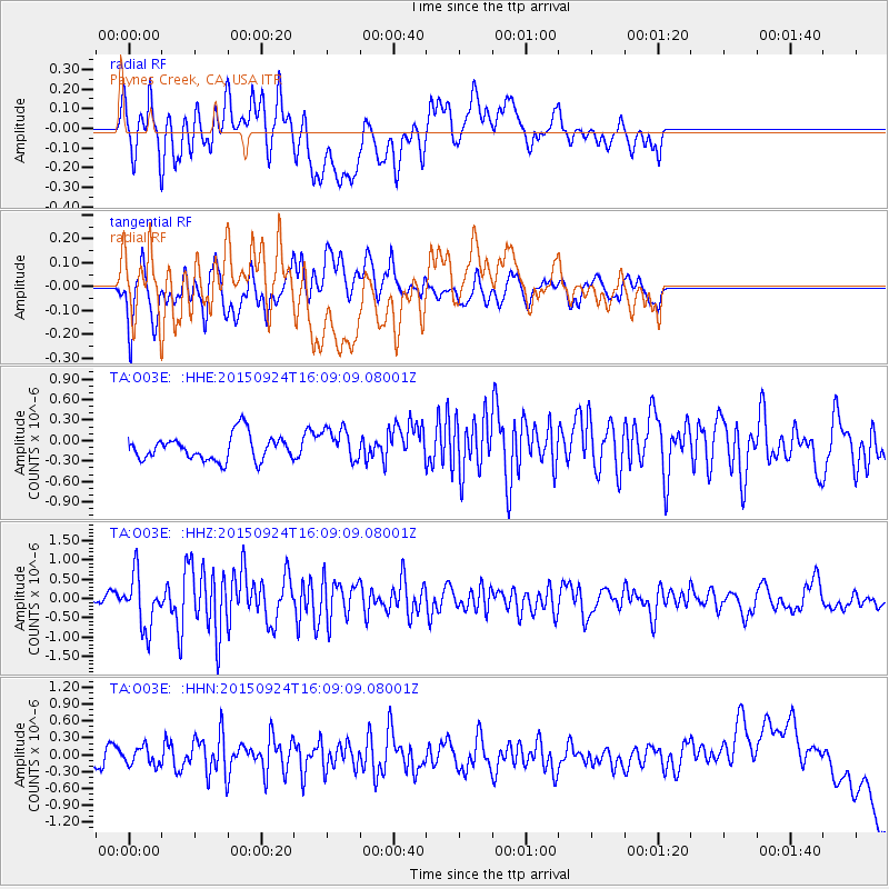
O03E Paynes Creek, CA, USA - Earthquake Result Viewer
*The percent match for this event was below the threshold and hence no stack was calculated.
| Earthquake location: |
Solomon Islands |
| Earthquake latitude/longitude: |
-10.1/160.5 |
| Earthquake time(UTC): |
2015/09/24 (267) 15:56:57 GMT |
| Earthquake Depth: |
23 km |
| Earthquake Magnitude: |
6.0 MB |
| Earthquake Catalog/Contributor: |
NEIC PDE/NEIC COMCAT |
|
| Network: |
TA USArray Transportable Network (new EarthScope stations) |
| Station: |
O03E Paynes Creek, CA, USA |
| Lat/Lon: |
40.29 N/121.80 W |
| Elevation: |
967 m |
|
| Distance: |
87.3 deg |
| Az: |
48.433 deg |
| Baz: |
254.38 deg |
| Ray Param: |
$rayparam |
*The percent match for this event was below the threshold and hence was not used in the summary stack. |
|
| Radial Match: |
22.87206 % |
| Radial Bump: |
400 |
| Transverse Match: |
46.023243 % |
| Transverse Bump: |
400 |
| SOD ConfigId: |
7422571 |
| Insert Time: |
2019-04-21 00:32:01.883 +0000 |
| GWidth: |
2.5 |
| Max Bumps: |
400 |
| Tol: |
0.001 |
|
Signal To Noise
| Channel | StoN | STA | LTA |
| TA:O03E: :HHZ:20150924T16:09:09.08001Z | 3.6131089 | 6.895235E-7 | 1.908394E-7 |
| TA:O03E: :HHN:20150924T16:09:09.08001Z | 0.8086422 | 1.5883519E-7 | 1.964221E-7 |
| TA:O03E: :HHE:20150924T16:09:09.08001Z | 1.1934931 | 2.2153502E-7 | 1.8561902E-7 |
| Arrivals |
| Ps | |
| PpPs | |
| PsPs/PpSs | |


