You are here: Home > Network List > 7A - Mid-Atlantic Geophysical Integrative Collaboration Stations List
> Station CABN Riverton, West Virginia USA > Earthquake Result Viewer
CABN Riverton, West Virginia USA - Earthquake Result Viewer
| Earthquake location: |
Near Coast Of Central Chile |
| Earthquake latitude/longitude: |
-30.8/-71.4 |
| Earthquake time(UTC): |
2015/09/26 (269) 02:51:18 GMT |
| Earthquake Depth: |
38 km |
| Earthquake Magnitude: |
6.2 MO |
| Earthquake Catalog/Contributor: |
NEIC PDE/NEIC ALERT |
|
| Network: |
7A Mid-Atlantic Geophysical Integrative Collaboration |
| Station: |
CABN Riverton, West Virginia USA |
| Lat/Lon: |
38.72 N/79.44 W |
| Elevation: |
910 m |
|
| Distance: |
69.6 deg |
| Az: |
353.283 deg |
| Baz: |
172.609 deg |
| Ray Param: |
0.05548209 |
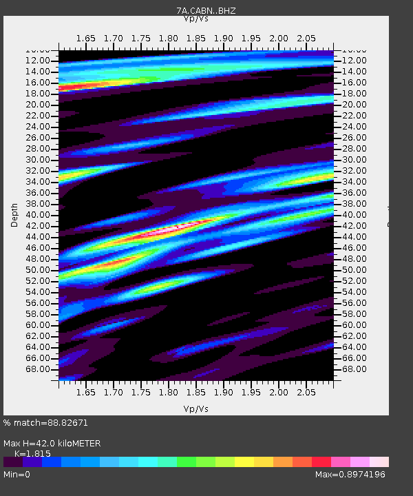
| Estimated Moho Depth: |
42.0 km |
| Estimated Crust Vp/Vs: |
1.82 |
| Assumed Crust Vp: |
6.159 km/s |
| Estimated Crust Vs: |
3.393 km/s |
| Estimated Crust Poisson's Ratio: |
0.28 |
|
| Radial Match: |
88.82671 % |
| Radial Bump: |
400 |
| Transverse Match: |
85.18122 % |
| Transverse Bump: |
400 |
| SOD ConfigId: |
7422571 |
| Insert Time: |
2019-04-21 00:35:34.283 +0000 |
| GWidth: |
2.5 |
| Max Bumps: |
400 |
| Tol: |
0.001 |
|

Signal To Noise
| Channel | StoN | STA | LTA |
| 7A:CABN: :BHZ:20150926T03:01:52.290027Z | 24.667418 | 4.6487457E-6 | 1.8845692E-7 |
| 7A:CABN: :BHN:20150926T03:01:52.290027Z | 9.528904 | 2.1366072E-6 | 2.2422383E-7 |
| 7A:CABN: :BHE:20150926T03:01:52.290027Z | 3.7510858 | 8.648402E-7 | 2.305573E-7 |
| Arrivals |
| Ps | 5.7 SECOND |
| PpPs | 19 SECOND |
| PsPs/PpSs | 24 SECOND |


