You are here: Home > Network List > 7A - Mid-Atlantic Geophysical Integrative Collaboration Stations List
> Station CAKE Sugar Grove, West Virginia USA > Earthquake Result Viewer
CAKE Sugar Grove, West Virginia USA - Earthquake Result Viewer
| Earthquake location: |
Near Coast Of Central Chile |
| Earthquake latitude/longitude: |
-30.8/-71.4 |
| Earthquake time(UTC): |
2015/09/26 (269) 02:51:18 GMT |
| Earthquake Depth: |
38 km |
| Earthquake Magnitude: |
6.2 MO |
| Earthquake Catalog/Contributor: |
NEIC PDE/NEIC ALERT |
|
| Network: |
7A Mid-Atlantic Geophysical Integrative Collaboration |
| Station: |
CAKE Sugar Grove, West Virginia USA |
| Lat/Lon: |
38.52 N/79.30 W |
| Elevation: |
640 m |
|
| Distance: |
69.4 deg |
| Az: |
353.372 deg |
| Baz: |
172.728 deg |
| Ray Param: |
0.055624288 |
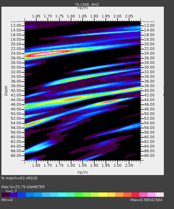
| Estimated Moho Depth: |
23.75 km |
| Estimated Crust Vp/Vs: |
1.70 |
| Assumed Crust Vp: |
6.159 km/s |
| Estimated Crust Vs: |
3.623 km/s |
| Estimated Crust Poisson's Ratio: |
0.24 |
|
| Radial Match: |
92.49028 % |
| Radial Bump: |
400 |
| Transverse Match: |
75.29485 % |
| Transverse Bump: |
400 |
| SOD ConfigId: |
7422571 |
| Insert Time: |
2019-04-21 00:35:34.756 +0000 |
| GWidth: |
2.5 |
| Max Bumps: |
400 |
| Tol: |
0.001 |
|

Signal To Noise
| Channel | StoN | STA | LTA |
| 7A:CAKE: :BHZ:20150926T03:01:50.96001Z | 25.760294 | 4.9847254E-6 | 1.935042E-7 |
| 7A:CAKE: :BHN:20150926T03:01:50.96001Z | 9.831279 | 2.2393845E-6 | 2.277816E-7 |
| 7A:CAKE: :BHE:20150926T03:01:50.96001Z | 3.7557259 | 7.882076E-7 | 2.0986825E-7 |
| Arrivals |
| Ps | 2.8 SECOND |
| PpPs | 10 SECOND |
| PsPs/PpSs | 13 SECOND |


