You are here: Home > Network List > 7A - Mid-Atlantic Geophysical Integrative Collaboration Stations List
> Station DENI Denison University at Granville, Ohio USA > Earthquake Result Viewer
DENI Denison University at Granville, Ohio USA - Earthquake Result Viewer
| Earthquake location: |
Near Coast Of Central Chile |
| Earthquake latitude/longitude: |
-30.8/-71.4 |
| Earthquake time(UTC): |
2015/09/26 (269) 02:51:18 GMT |
| Earthquake Depth: |
38 km |
| Earthquake Magnitude: |
6.2 MO |
| Earthquake Catalog/Contributor: |
NEIC PDE/NEIC ALERT |
|
| Network: |
7A Mid-Atlantic Geophysical Integrative Collaboration |
| Station: |
DENI Denison University at Granville, Ohio USA |
| Lat/Lon: |
40.08 N/82.53 W |
| Elevation: |
315 m |
|
| Distance: |
71.3 deg |
| Az: |
350.995 deg |
| Baz: |
169.892 deg |
| Ray Param: |
0.05435827 |
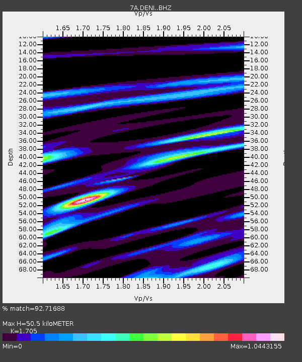
| Estimated Moho Depth: |
50.5 km |
| Estimated Crust Vp/Vs: |
1.71 |
| Assumed Crust Vp: |
6.498 km/s |
| Estimated Crust Vs: |
3.811 km/s |
| Estimated Crust Poisson's Ratio: |
0.24 |
|
| Radial Match: |
92.71688 % |
| Radial Bump: |
311 |
| Transverse Match: |
70.61622 % |
| Transverse Bump: |
400 |
| SOD ConfigId: |
7422571 |
| Insert Time: |
2019-04-21 00:35:35.268 +0000 |
| GWidth: |
2.5 |
| Max Bumps: |
400 |
| Tol: |
0.001 |
|

Signal To Noise
| Channel | StoN | STA | LTA |
| 7A:DENI: :BHZ:20150926T03:02:02.68999Z | 14.708673 | 3.9549623E-6 | 2.6888642E-7 |
| 7A:DENI: :BHN:20150926T03:02:02.68999Z | 16.969397 | 2.1858025E-6 | 1.288085E-7 |
| 7A:DENI: :BHE:20150926T03:02:02.68999Z | 2.6443079 | 6.756734E-7 | 2.5551995E-7 |
| Arrivals |
| Ps | 5.7 SECOND |
| PpPs | 20 SECOND |
| PsPs/PpSs | 26 SECOND |


