You are here: Home > Network List > 7A - Mid-Atlantic Geophysical Integrative Collaboration Stations List
> Station LADY Linville, Virginia USA > Earthquake Result Viewer
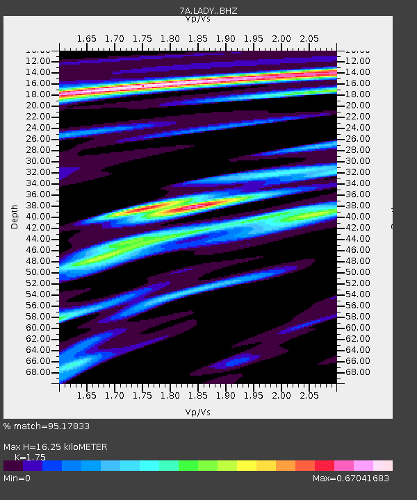
LADY Linville, Virginia USA - Earthquake Result Viewer
| Earthquake location: |
Near Coast Of Central Chile |
| Earthquake latitude/longitude: |
-30.8/-71.4 |
| Earthquake time(UTC): |
2015/09/26 (269) 02:51:18 GMT |
| Earthquake Depth: |
38 km |
| Earthquake Magnitude: |
6.2 MO |
| Earthquake Catalog/Contributor: |
NEIC PDE/NEIC ALERT |
|
| Network: |
7A Mid-Atlantic Geophysical Integrative Collaboration |
| Station: |
LADY Linville, Virginia USA |
| Lat/Lon: |
38.51 N/78.76 W |
| Elevation: |
401 m |
|
| Distance: |
69.3 deg |
| Az: |
353.817 deg |
| Baz: |
173.217 deg |
| Ray Param: |
0.055666402 |
| Estimated Moho Depth: |
16.25 km |
| Estimated Crust Vp/Vs: |
1.75 |
| Assumed Crust Vp: |
6.159 km/s |
| Estimated Crust Vs: |
3.519 km/s |
| Estimated Crust Poisson's Ratio: |
0.26 |
|
| Radial Match: |
95.17833 % |
| Radial Bump: |
400 |
| Transverse Match: |
87.50626 % |
| Transverse Bump: |
400 |
| SOD ConfigId: |
7422571 |
| Insert Time: |
2019-04-21 00:35:40.083 +0000 |
| GWidth: |
2.5 |
| Max Bumps: |
400 |
| Tol: |
0.001 |
|

Signal To Noise
| Channel | StoN | STA | LTA |
| 7A:LADY: :BHZ:20150926T03:01:50.56499Z | 34.025436 | 5.0587173E-6 | 1.4867457E-7 |
| 7A:LADY: :BHN:20150926T03:01:50.56499Z | 17.20301 | 1.9697534E-6 | 1.145005E-7 |
| 7A:LADY: :BHE:20150926T03:01:50.56499Z | 1.8079727 | 2.5941642E-7 | 1.434847E-7 |
| Arrivals |
| Ps | 2.0 SECOND |
| PpPs | 7.0 SECOND |
| PsPs/PpSs | 9.1 SECOND |


