You are here: Home > Network List > AZ - ANZA Regional Network Stations List
> Station RRSP RRSP, CA, USA > Earthquake Result Viewer
RRSP RRSP, CA, USA - Earthquake Result Viewer
| Earthquake location: |
Near Coast Of Central Chile |
| Earthquake latitude/longitude: |
-30.8/-71.4 |
| Earthquake time(UTC): |
2015/09/26 (269) 02:51:18 GMT |
| Earthquake Depth: |
38 km |
| Earthquake Magnitude: |
6.2 MO |
| Earthquake Catalog/Contributor: |
NEIC PDE/NEIC ALERT |
|
| Network: |
AZ ANZA Regional Network |
| Station: |
RRSP RRSP, CA, USA |
| Lat/Lon: |
33.65 N/116.74 W |
| Elevation: |
1610 m |
|
| Distance: |
77.1 deg |
| Az: |
322.497 deg |
| Baz: |
141.106 deg |
| Ray Param: |
0.050485894 |
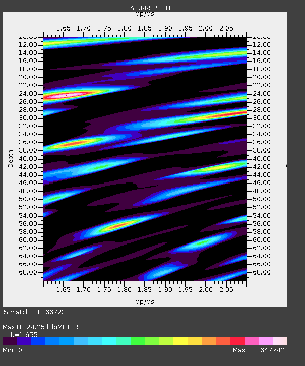
| Estimated Moho Depth: |
24.25 km |
| Estimated Crust Vp/Vs: |
1.65 |
| Assumed Crust Vp: |
6.264 km/s |
| Estimated Crust Vs: |
3.785 km/s |
| Estimated Crust Poisson's Ratio: |
0.21 |
|
| Radial Match: |
81.66723 % |
| Radial Bump: |
400 |
| Transverse Match: |
75.689445 % |
| Transverse Bump: |
400 |
| SOD ConfigId: |
7422571 |
| Insert Time: |
2019-04-21 00:36:12.269 +0000 |
| GWidth: |
2.5 |
| Max Bumps: |
400 |
| Tol: |
0.001 |
|

Signal To Noise
| Channel | StoN | STA | LTA |
| AZ:RRSP: :HHZ:20150926T03:02:36.574023Z | 16.637224 | 3.360158E-6 | 2.0196627E-7 |
| AZ:RRSP: :HHN:20150926T03:02:36.574023Z | 7.3142896 | 1.075521E-6 | 1.4704382E-7 |
| AZ:RRSP: :HHE:20150926T03:02:36.574023Z | 3.9219248 | 7.548006E-7 | 1.9245668E-7 |
| Arrivals |
| Ps | 2.6 SECOND |
| PpPs | 10.0 SECOND |
| PsPs/PpSs | 13 SECOND |


