You are here: Home > Network List > N4 - Central and EAstern US Network Stations List
> Station N49A Columbus Grove, OH, USA > Earthquake Result Viewer
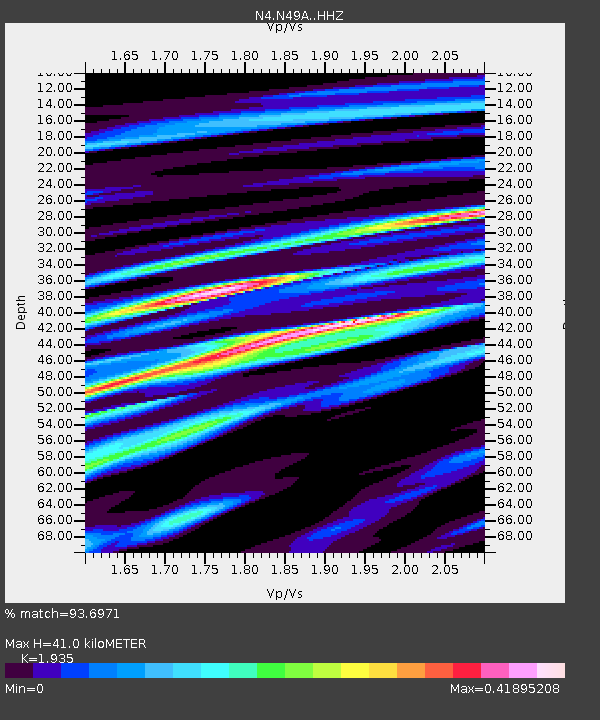
N49A Columbus Grove, OH, USA - Earthquake Result Viewer
| Earthquake location: |
Near Coast Of Central Chile |
| Earthquake latitude/longitude: |
-30.8/-71.4 |
| Earthquake time(UTC): |
2015/09/26 (269) 02:51:18 GMT |
| Earthquake Depth: |
38 km |
| Earthquake Magnitude: |
6.2 MO |
| Earthquake Catalog/Contributor: |
NEIC PDE/NEIC ALERT |
|
| Network: |
N4 Central and EAstern US Network |
| Station: |
N49A Columbus Grove, OH, USA |
| Lat/Lon: |
40.92 N/84.18 W |
| Elevation: |
225 m |
|
| Distance: |
72.4 deg |
| Az: |
349.856 deg |
| Baz: |
168.466 deg |
| Ray Param: |
0.05365078 |
| Estimated Moho Depth: |
41.0 km |
| Estimated Crust Vp/Vs: |
1.93 |
| Assumed Crust Vp: |
6.498 km/s |
| Estimated Crust Vs: |
3.358 km/s |
| Estimated Crust Poisson's Ratio: |
0.32 |
|
| Radial Match: |
93.6971 % |
| Radial Bump: |
197 |
| Transverse Match: |
78.01489 % |
| Transverse Bump: |
400 |
| SOD ConfigId: |
7422571 |
| Insert Time: |
2019-04-21 00:40:39.256 +0000 |
| GWidth: |
2.5 |
| Max Bumps: |
400 |
| Tol: |
0.001 |
|

Signal To Noise
| Channel | StoN | STA | LTA |
| N4:N49A: :HHZ:20150926T03:02:09.030017Z | 63.55383 | 7.258361E-6 | 1.14208085E-7 |
| N4:N49A: :HHN:20150926T03:02:09.030017Z | 28.536934 | 3.2891176E-6 | 1.1525827E-7 |
| N4:N49A: :HHE:20150926T03:02:09.030017Z | 11.91634 | 1.0264577E-6 | 8.613868E-8 |
| Arrivals |
| Ps | 6.1 SECOND |
| PpPs | 18 SECOND |
| PsPs/PpSs | 24 SECOND |


