You are here: Home > Network List > N4 - Central and EAstern US Network Stations List
> Station Q44B Vandalia, IL, USA > Earthquake Result Viewer
Q44B Vandalia, IL, USA - Earthquake Result Viewer
| Earthquake location: |
Near Coast Of Central Chile |
| Earthquake latitude/longitude: |
-30.8/-71.4 |
| Earthquake time(UTC): |
2015/09/26 (269) 02:51:18 GMT |
| Earthquake Depth: |
38 km |
| Earthquake Magnitude: |
6.2 MO |
| Earthquake Catalog/Contributor: |
NEIC PDE/NEIC ALERT |
|
| Network: |
N4 Central and EAstern US Network |
| Station: |
Q44B Vandalia, IL, USA |
| Lat/Lon: |
38.90 N/89.02 W |
| Elevation: |
168 m |
|
| Distance: |
71.3 deg |
| Az: |
345.55 deg |
| Baz: |
164.031 deg |
| Ray Param: |
0.05436726 |
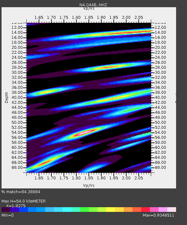
| Estimated Moho Depth: |
54.0 km |
| Estimated Crust Vp/Vs: |
1.83 |
| Assumed Crust Vp: |
6.444 km/s |
| Estimated Crust Vs: |
3.526 km/s |
| Estimated Crust Poisson's Ratio: |
0.29 |
|
| Radial Match: |
84.38884 % |
| Radial Bump: |
400 |
| Transverse Match: |
71.36921 % |
| Transverse Bump: |
400 |
| SOD ConfigId: |
7422571 |
| Insert Time: |
2019-04-21 00:40:52.377 +0000 |
| GWidth: |
2.5 |
| Max Bumps: |
400 |
| Tol: |
0.001 |
|

Signal To Noise
| Channel | StoN | STA | LTA |
| N4:Q44B: :HHZ:20150926T03:02:02.629993Z | 20.271778 | 3.7390216E-6 | 1.8444469E-7 |
| N4:Q44B: :HHN:20150926T03:02:02.629993Z | 7.476397 | 1.665714E-6 | 2.2279636E-7 |
| N4:Q44B: :HHE:20150926T03:02:02.629993Z | 3.8095691 | 7.5512725E-7 | 1.9821854E-7 |
| Arrivals |
| Ps | 7.2 SECOND |
| PpPs | 23 SECOND |
| PsPs/PpSs | 30 SECOND |


