You are here: Home > Network List > N4 - Central and EAstern US Network Stations List
> Station W57A Gilead, NC, USA > Earthquake Result Viewer
W57A Gilead, NC, USA - Earthquake Result Viewer
| Earthquake location: |
Near Coast Of Central Chile |
| Earthquake latitude/longitude: |
-30.8/-71.4 |
| Earthquake time(UTC): |
2015/09/26 (269) 02:51:18 GMT |
| Earthquake Depth: |
38 km |
| Earthquake Magnitude: |
6.2 MO |
| Earthquake Catalog/Contributor: |
NEIC PDE/NEIC ALERT |
|
| Network: |
N4 Central and EAstern US Network |
| Station: |
W57A Gilead, NC, USA |
| Lat/Lon: |
35.15 N/79.99 W |
| Elevation: |
85 m |
|
| Distance: |
66.1 deg |
| Az: |
352.292 deg |
| Baz: |
171.906 deg |
| Ray Param: |
0.057757124 |
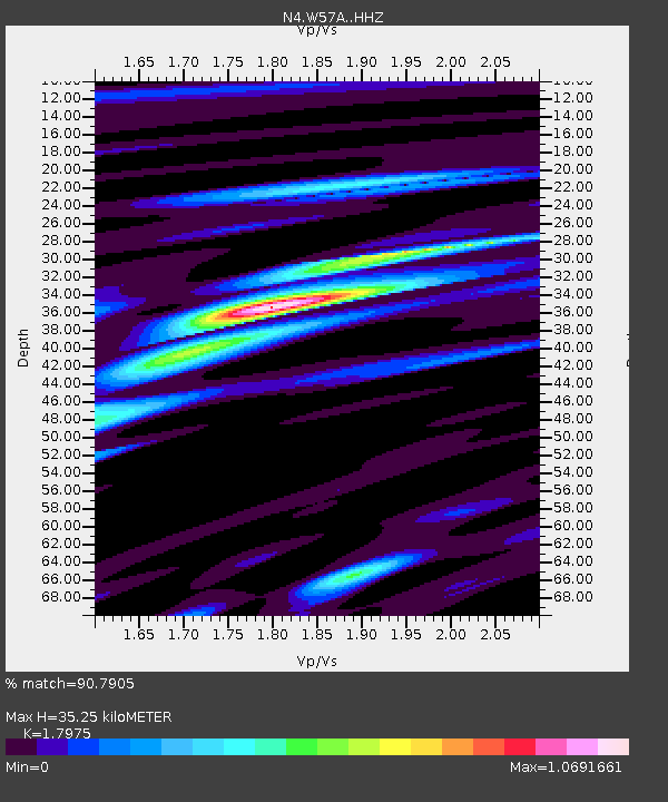
| Estimated Moho Depth: |
35.25 km |
| Estimated Crust Vp/Vs: |
1.80 |
| Assumed Crust Vp: |
6.565 km/s |
| Estimated Crust Vs: |
3.652 km/s |
| Estimated Crust Poisson's Ratio: |
0.28 |
|
| Radial Match: |
90.7905 % |
| Radial Bump: |
377 |
| Transverse Match: |
74.11034 % |
| Transverse Bump: |
400 |
| SOD ConfigId: |
7422571 |
| Insert Time: |
2019-04-21 00:41:23.966 +0000 |
| GWidth: |
2.5 |
| Max Bumps: |
400 |
| Tol: |
0.001 |
|

Signal To Noise
| Channel | StoN | STA | LTA |
| N4:W57A: :HHZ:20150926T03:01:30.530017Z | 20.027903 | 3.861186E-6 | 1.9279035E-7 |
| N4:W57A: :HHN:20150926T03:01:30.530017Z | 17.460201 | 1.6729006E-6 | 9.581222E-8 |
| N4:W57A: :HHE:20150926T03:01:30.530017Z | 3.0824199 | 4.7752496E-7 | 1.5491887E-7 |
| Arrivals |
| Ps | 4.5 SECOND |
| PpPs | 14 SECOND |
| PsPs/PpSs | 19 SECOND |


