You are here: Home > Network List > IU - Global Seismograph Network (GSN - IRIS/USGS) Stations List
> Station TEIG Tepich, Yucatan, Mexico > Earthquake Result Viewer
TEIG Tepich, Yucatan, Mexico - Earthquake Result Viewer
| Earthquake location: |
Off East Coast Of Kamchatka |
| Earthquake latitude/longitude: |
52.1/159.5 |
| Earthquake time(UTC): |
1999/03/08 (067) 12:25:48 GMT |
| Earthquake Depth: |
57 km |
| Earthquake Magnitude: |
5.7 MB, 6.9 MW, 6.8 MW |
| Earthquake Catalog/Contributor: |
WHDF/NEIC |
|
| Network: |
IU Global Seismograph Network (GSN - IRIS/USGS) |
| Station: |
TEIG Tepich, Yucatan, Mexico |
| Lat/Lon: |
20.23 N/88.28 W |
| Elevation: |
69 m |
|
| Distance: |
87.1 deg |
| Az: |
60.527 deg |
| Baz: |
325.081 deg |
| Ray Param: |
0.043494023 |
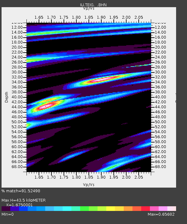
| Estimated Moho Depth: |
43.5 km |
| Estimated Crust Vp/Vs: |
1.68 |
| Assumed Crust Vp: |
5.817 km/s |
| Estimated Crust Vs: |
3.473 km/s |
| Estimated Crust Poisson's Ratio: |
0.22 |
|
| Radial Match: |
91.52498 % |
| Radial Bump: |
400 |
| Transverse Match: |
79.23179 % |
| Transverse Bump: |
400 |
| SOD ConfigId: |
4480 |
| Insert Time: |
2010-03-04 20:42:02.340 +0000 |
| GWidth: |
2.5 |
| Max Bumps: |
400 |
| Tol: |
0.001 |
|
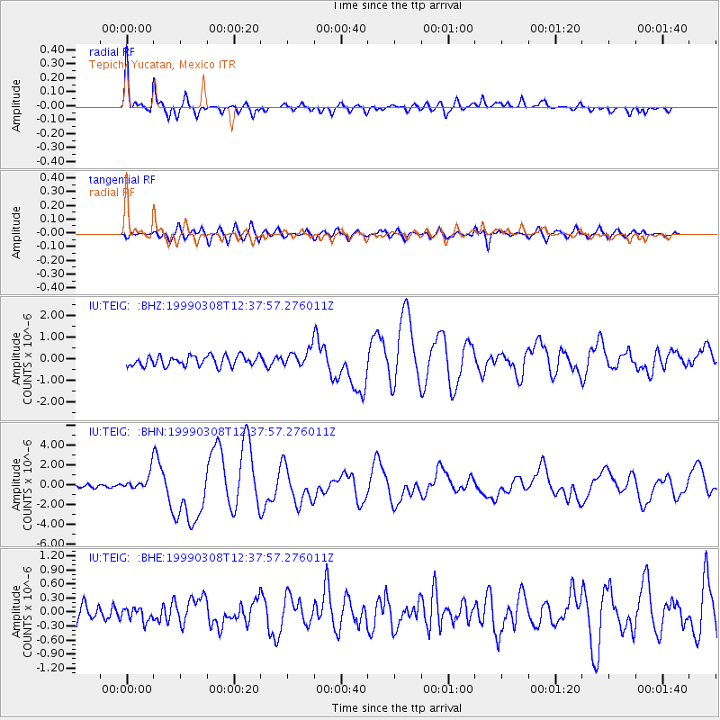
Signal To Noise
| Channel | StoN | STA | LTA |
| IU:TEIG: :BHN:19990308T12:37:57.276011Z | 4.5809417 | 9.09876E-7 | 1.9862203E-7 |
| IU:TEIG: :BHE:19990308T12:37:57.276011Z | 0.76046944 | 1.4615647E-7 | 1.9219243E-7 |
| IU:TEIG: :BHZ:19990308T12:37:57.276011Z | 1.6698977 | 3.9421263E-7 | 2.3606992E-7 |
| Arrivals |
| Ps | 5.1 SECOND |
| PpPs | 20 SECOND |
| PsPs/PpSs | 25 SECOND |


