You are here: Home > Network List > TA - USArray Transportable Network (new EarthScope stations) Stations List
> Station ABTX Abilene, Hawley, TX, USA > Earthquake Result Viewer
ABTX Abilene, Hawley, TX, USA - Earthquake Result Viewer

| Earthquake location: |
Near Coast Of Central Chile |
| Earthquake latitude/longitude: |
-30.8/-71.4 |
| Earthquake time(UTC): |
2015/09/26 (269) 02:51:18 GMT |
| Earthquake Depth: |
38 km |
| Earthquake Magnitude: |
6.2 MO |
| Earthquake Catalog/Contributor: |
NEIC PDE/NEIC ALERT |
|
| Network: |
TA USArray Transportable Network (new EarthScope stations) |
| Station: |
ABTX Abilene, Hawley, TX, USA |
| Lat/Lon: |
32.62 N/99.64 W |
| Elevation: |
502 m |
|
| Distance: |
68.5 deg |
| Az: |
334.577 deg |
| Baz: |
154.046 deg |
| Ray Param: |
0.056175347 |
| Estimated Moho Depth: |
29.75 km |
| Estimated Crust Vp/Vs: |
2.06 |
| Assumed Crust Vp: |
6.426 km/s |
| Estimated Crust Vs: |
3.116 km/s |
| Estimated Crust Poisson's Ratio: |
0.35 |
|
| Radial Match: |
95.50947 % |
| Radial Bump: |
342 |
| Transverse Match: |
79.02169 % |
| Transverse Bump: |
400 |
| SOD ConfigId: |
7422571 |
| Insert Time: |
2019-04-21 00:44:19.202 +0000 |
| GWidth: |
2.5 |
| Max Bumps: |
400 |
| Tol: |
0.001 |
|
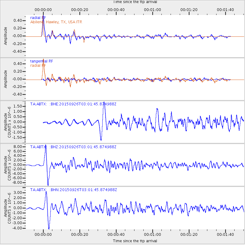
Signal To Noise
| Channel | StoN | STA | LTA |
| TA:ABTX: :BHZ:20150926T03:01:45.874988Z | 36.35704 | 4.4344206E-6 | 1.219687E-7 |
| TA:ABTX: :BHN:20150926T03:01:45.874988Z | 19.312943 | 1.994758E-6 | 1.0328607E-7 |
| TA:ABTX: :BHE:20150926T03:01:45.874988Z | 7.402055 | 1.0215515E-6 | 1.3800918E-7 |
| Arrivals |
| Ps | 5.1 SECOND |
| PpPs | 14 SECOND |
| PsPs/PpSs | 19 SECOND |


