You are here: Home > Network List > TA - USArray Transportable Network (new EarthScope stations) Stations List
> Station G03D McMinnville, OR, USA > Earthquake Result Viewer
G03D McMinnville, OR, USA - Earthquake Result Viewer
| Earthquake location: |
Near Coast Of Central Chile |
| Earthquake latitude/longitude: |
-30.8/-71.4 |
| Earthquake time(UTC): |
2015/09/26 (269) 02:51:18 GMT |
| Earthquake Depth: |
38 km |
| Earthquake Magnitude: |
6.2 MO |
| Earthquake Catalog/Contributor: |
NEIC PDE/NEIC ALERT |
|
| Network: |
TA USArray Transportable Network (new EarthScope stations) |
| Station: |
G03D McMinnville, OR, USA |
| Lat/Lon: |
45.21 N/123.26 W |
| Elevation: |
222 m |
|
| Distance: |
89.2 deg |
| Az: |
326.209 deg |
| Baz: |
137.401 deg |
| Ray Param: |
0.042006716 |
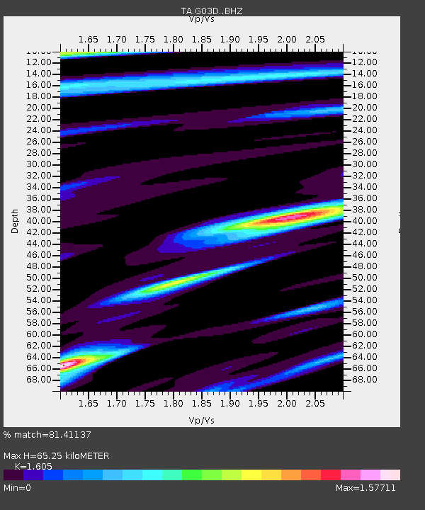
| Estimated Moho Depth: |
65.25 km |
| Estimated Crust Vp/Vs: |
1.61 |
| Assumed Crust Vp: |
6.566 km/s |
| Estimated Crust Vs: |
4.091 km/s |
| Estimated Crust Poisson's Ratio: |
0.18 |
|
| Radial Match: |
81.41137 % |
| Radial Bump: |
400 |
| Transverse Match: |
66.657455 % |
| Transverse Bump: |
400 |
| SOD ConfigId: |
7422571 |
| Insert Time: |
2019-04-21 00:44:24.884 +0000 |
| GWidth: |
2.5 |
| Max Bumps: |
400 |
| Tol: |
0.001 |
|
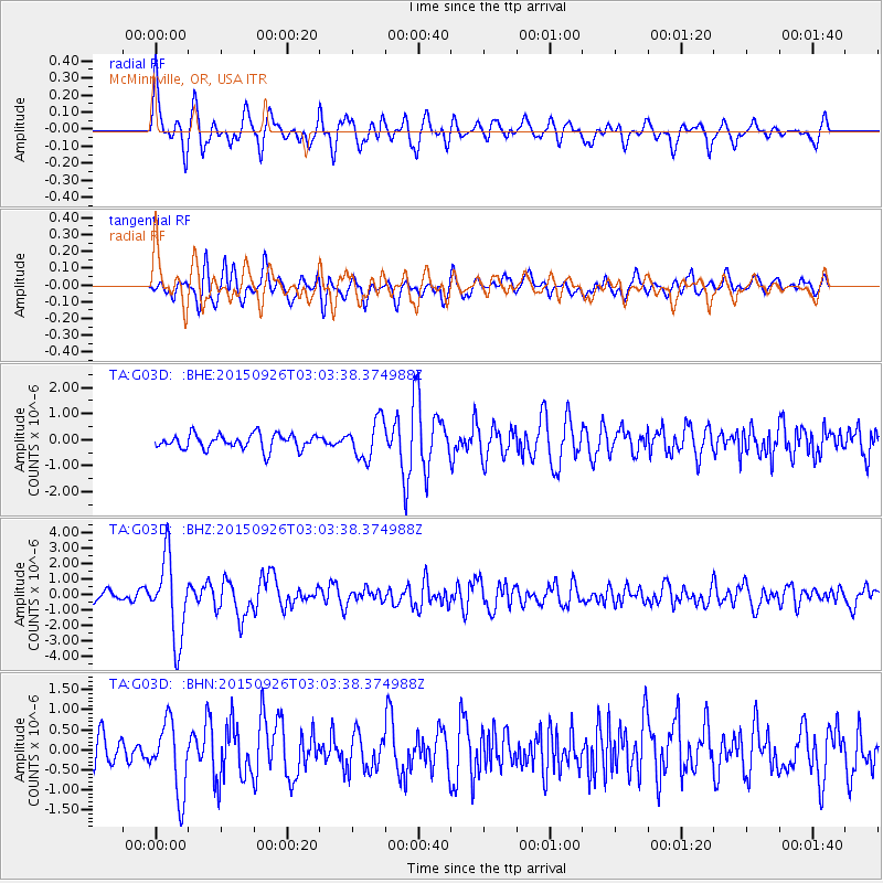
Signal To Noise
| Channel | StoN | STA | LTA |
| TA:G03D: :BHZ:20150926T03:03:38.374988Z | 9.673331 | 2.5862228E-6 | 2.6735594E-7 |
| TA:G03D: :BHN:20150926T03:03:38.374988Z | 2.5808601 | 8.773346E-7 | 3.3993882E-7 |
| TA:G03D: :BHE:20150926T03:03:38.374988Z | 2.5591116 | 7.3994033E-7 | 2.8913954E-7 |
| Arrivals |
| Ps | 6.2 SECOND |
| PpPs | 25 SECOND |
| PsPs/PpSs | 31 SECOND |


