You are here: Home > Network List > IU - Global Seismograph Network (GSN - IRIS/USGS) Stations List
> Station TEIG Tepich, Yucatan, Mexico > Earthquake Result Viewer
TEIG Tepich, Yucatan, Mexico - Earthquake Result Viewer

| Earthquake location: |
Fiji Islands Region |
| Earthquake latitude/longitude: |
-21.4/-176.5 |
| Earthquake time(UTC): |
1999/04/13 (103) 10:38:48 GMT |
| Earthquake Depth: |
164 km |
| Earthquake Magnitude: |
6.4 MB, 6.8 MW, 6.8 MW |
| Earthquake Catalog/Contributor: |
WHDF/NEIC |
|
| Network: |
IU Global Seismograph Network (GSN - IRIS/USGS) |
| Station: |
TEIG Tepich, Yucatan, Mexico |
| Lat/Lon: |
20.23 N/88.28 W |
| Elevation: |
69 m |
|
| Distance: |
95.6 deg |
| Az: |
70.573 deg |
| Baz: |
249.341 deg |
| Ray Param: |
0.040620886 |
| Estimated Moho Depth: |
34.75 km |
| Estimated Crust Vp/Vs: |
1.86 |
| Assumed Crust Vp: |
5.817 km/s |
| Estimated Crust Vs: |
3.128 km/s |
| Estimated Crust Poisson's Ratio: |
0.30 |
|
| Radial Match: |
91.09137 % |
| Radial Bump: |
400 |
| Transverse Match: |
71.10907 % |
| Transverse Bump: |
400 |
| SOD ConfigId: |
4480 |
| Insert Time: |
2010-03-04 20:42:08.439 +0000 |
| GWidth: |
2.5 |
| Max Bumps: |
400 |
| Tol: |
0.001 |
|
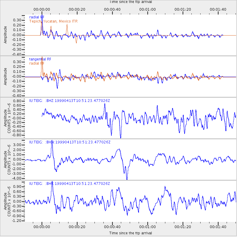
Signal To Noise
| Channel | StoN | STA | LTA |
| IU:TEIG: :BHN:19990413T10:51:23.477026Z | 6.4092197 | 4.564586E-7 | 7.1219056E-8 |
| IU:TEIG: :BHE:19990413T10:51:23.477026Z | 1.9903712 | 1.2274671E-7 | 6.1670264E-8 |
| IU:TEIG: :BHZ:19990413T10:51:23.477026Z | 0.76362455 | 1.134743E-7 | 1.485996E-7 |
| Arrivals |
| Ps | 5.2 SECOND |
| PpPs | 17 SECOND |
| PsPs/PpSs | 22 SECOND |


