You are here: Home > Network List > TA - USArray Transportable Network (new EarthScope stations) Stations List
> Station L61B Northampton, MA, USA > Earthquake Result Viewer
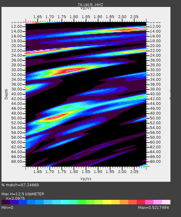
L61B Northampton, MA, USA - Earthquake Result Viewer
| Earthquake location: |
Near Coast Of Central Chile |
| Earthquake latitude/longitude: |
-30.8/-71.4 |
| Earthquake time(UTC): |
2015/09/26 (269) 02:51:18 GMT |
| Earthquake Depth: |
38 km |
| Earthquake Magnitude: |
6.2 MO |
| Earthquake Catalog/Contributor: |
NEIC PDE/NEIC ALERT |
|
| Network: |
TA USArray Transportable Network (new EarthScope stations) |
| Station: |
L61B Northampton, MA, USA |
| Lat/Lon: |
42.45 N/72.68 W |
| Elevation: |
261 m |
|
| Distance: |
72.9 deg |
| Az: |
358.998 deg |
| Baz: |
178.835 deg |
| Ray Param: |
0.05328426 |
| Estimated Moho Depth: |
12.5 km |
| Estimated Crust Vp/Vs: |
2.10 |
| Assumed Crust Vp: |
6.419 km/s |
| Estimated Crust Vs: |
3.06 km/s |
| Estimated Crust Poisson's Ratio: |
0.35 |
|
| Radial Match: |
87.24668 % |
| Radial Bump: |
299 |
| Transverse Match: |
60.140453 % |
| Transverse Bump: |
359 |
| SOD ConfigId: |
7422571 |
| Insert Time: |
2019-04-21 00:44:40.812 +0000 |
| GWidth: |
2.5 |
| Max Bumps: |
400 |
| Tol: |
0.001 |
|

Signal To Noise
| Channel | StoN | STA | LTA |
| TA:L61B: :HHZ:20150926T03:02:12.299976Z | 10.165403 | 3.8099524E-6 | 3.74796E-7 |
| TA:L61B: :HHN:20150926T03:02:12.299976Z | 7.005919 | 1.8100059E-6 | 2.583538E-7 |
| TA:L61B: :HHE:20150926T03:02:12.299976Z | 1.3136817 | 3.538371E-7 | 2.6934765E-7 |
| Arrivals |
| Ps | 2.2 SECOND |
| PpPs | 5.9 SECOND |
| PsPs/PpSs | 8.1 SECOND |


