You are here: Home > Network List > IU - Global Seismograph Network (GSN - IRIS/USGS) Stations List
> Station TEIG Tepich, Yucatan, Mexico > Earthquake Result Viewer
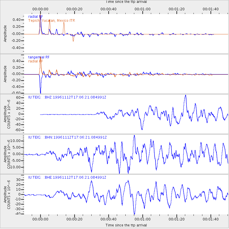
TEIG Tepich, Yucatan, Mexico - Earthquake Result Viewer

| Earthquake location: |
Near Coast Of Peru |
| Earthquake latitude/longitude: |
-15.0/-75.7 |
| Earthquake time(UTC): |
1996/11/12 (317) 16:59:44 GMT |
| Earthquake Depth: |
33 km |
| Earthquake Magnitude: |
6.5 MB, 7.3 MS, 7.7 UNKNOWN, 7.7 MW |
| Earthquake Catalog/Contributor: |
WHDF/NEIC |
|
| Network: |
IU Global Seismograph Network (GSN - IRIS/USGS) |
| Station: |
TEIG Tepich, Yucatan, Mexico |
| Lat/Lon: |
20.23 N/88.28 W |
| Elevation: |
69 m |
|
| Distance: |
37.1 deg |
| Az: |
340.157 deg |
| Baz: |
159.555 deg |
| Ray Param: |
0.076244384 |
| Estimated Moho Depth: |
48.25 km |
| Estimated Crust Vp/Vs: |
2.10 |
| Assumed Crust Vp: |
5.817 km/s |
| Estimated Crust Vs: |
2.773 km/s |
| Estimated Crust Poisson's Ratio: |
0.35 |
|
| Radial Match: |
98.23966 % |
| Radial Bump: |
219 |
| Transverse Match: |
98.95588 % |
| Transverse Bump: |
236 |
| SOD ConfigId: |
6273 |
| Insert Time: |
2010-03-04 20:42:09.717 +0000 |
| GWidth: |
2.5 |
| Max Bumps: |
400 |
| Tol: |
0.001 |
|
Signal To Noise
| Channel | StoN | STA | LTA |
| IU:TEIG: :BHN:19961112T17:06:21.084991Z | 2.621341 | 6.071644E-7 | 2.3162359E-7 |
| IU:TEIG: :BHE:19961112T17:06:21.084991Z | 2.85699 | 1.2979839E-6 | 4.5431867E-7 |
| IU:TEIG: :BHZ:19961112T17:06:21.084991Z | 6.007827 | 2.1969229E-6 | 3.6567678E-7 |
| Arrivals |
| Ps | 9.6 SECOND |
| PpPs | 24 SECOND |
| PsPs/PpSs | 34 SECOND |


