You are here: Home > Network List > IU - Global Seismograph Network (GSN - IRIS/USGS) Stations List
> Station TEIG Tepich, Yucatan, Mexico > Earthquake Result Viewer
TEIG Tepich, Yucatan, Mexico - Earthquake Result Viewer
| Earthquake location: |
Northern Chile |
| Earthquake latitude/longitude: |
-22.7/-68.5 |
| Earthquake time(UTC): |
1999/03/02 (061) 17:45:55 GMT |
| Earthquake Depth: |
111 km |
| Earthquake Magnitude: |
5.8 MB, 6.1 MW, 5.9 MW |
| Earthquake Catalog/Contributor: |
WHDF/NEIC |
|
| Network: |
IU Global Seismograph Network (GSN - IRIS/USGS) |
| Station: |
TEIG Tepich, Yucatan, Mexico |
| Lat/Lon: |
20.23 N/88.28 W |
| Elevation: |
69 m |
|
| Distance: |
46.8 deg |
| Az: |
334.182 deg |
| Baz: |
154.646 deg |
| Ray Param: |
0.06999467 |
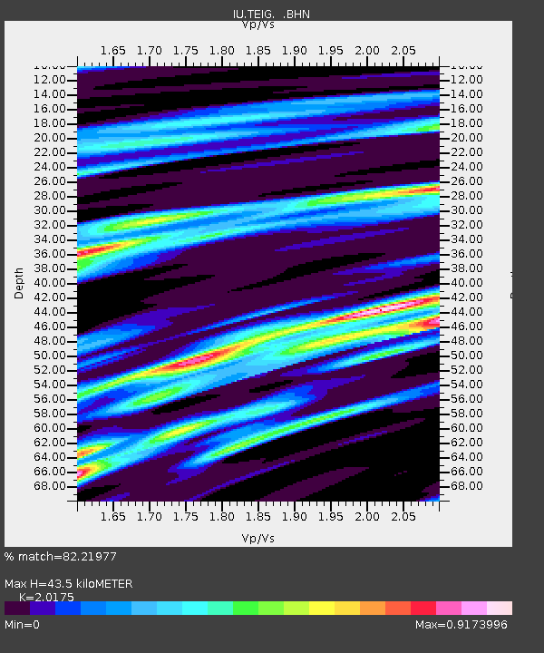
| Estimated Moho Depth: |
43.5 km |
| Estimated Crust Vp/Vs: |
2.02 |
| Assumed Crust Vp: |
5.817 km/s |
| Estimated Crust Vs: |
2.883 km/s |
| Estimated Crust Poisson's Ratio: |
0.34 |
|
| Radial Match: |
82.21977 % |
| Radial Bump: |
400 |
| Transverse Match: |
68.483246 % |
| Transverse Bump: |
400 |
| SOD ConfigId: |
4480 |
| Insert Time: |
2010-03-04 20:42:13.225 +0000 |
| GWidth: |
2.5 |
| Max Bumps: |
400 |
| Tol: |
0.001 |
|

Signal To Noise
| Channel | StoN | STA | LTA |
| IU:TEIG: :BHN:19990302T17:53:43.528013Z | 13.240115 | 2.2935883E-6 | 1.7323023E-7 |
| IU:TEIG: :BHE:19990302T17:53:43.528013Z | 3.3919947 | 3.9668492E-7 | 1.1694739E-7 |
| IU:TEIG: :BHZ:19990302T17:53:43.528013Z | 4.906019 | 1.0686402E-6 | 2.1782228E-7 |
| Arrivals |
| Ps | 7.9 SECOND |
| PpPs | 22 SECOND |
| PsPs/PpSs | 30 SECOND |


