You are here: Home > Network List > TA - USArray Transportable Network (new EarthScope stations) Stations List
> Station P52A Corning, OH, USA > Earthquake Result Viewer
P52A Corning, OH, USA - Earthquake Result Viewer
| Earthquake location: |
Near Coast Of Central Chile |
| Earthquake latitude/longitude: |
-30.8/-71.4 |
| Earthquake time(UTC): |
2015/09/26 (269) 02:51:18 GMT |
| Earthquake Depth: |
38 km |
| Earthquake Magnitude: |
6.2 MO |
| Earthquake Catalog/Contributor: |
NEIC PDE/NEIC ALERT |
|
| Network: |
TA USArray Transportable Network (new EarthScope stations) |
| Station: |
P52A Corning, OH, USA |
| Lat/Lon: |
39.63 N/82.13 W |
| Elevation: |
293 m |
|
| Distance: |
70.8 deg |
| Az: |
351.229 deg |
| Baz: |
170.22 deg |
| Ray Param: |
0.054676995 |
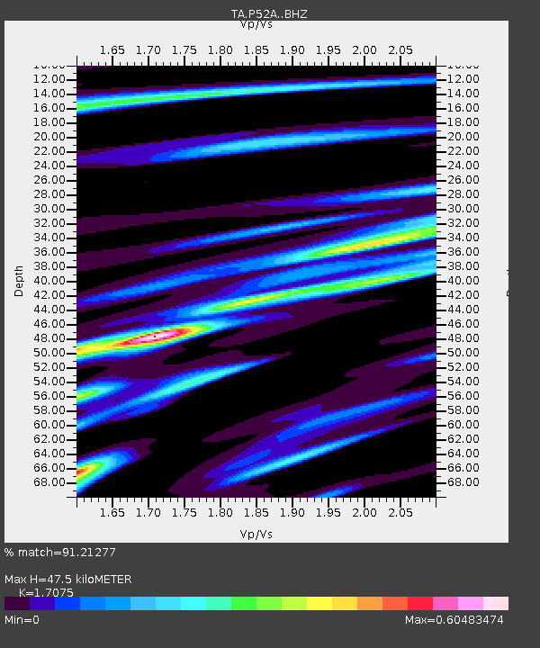
| Estimated Moho Depth: |
47.5 km |
| Estimated Crust Vp/Vs: |
1.71 |
| Assumed Crust Vp: |
6.232 km/s |
| Estimated Crust Vs: |
3.65 km/s |
| Estimated Crust Poisson's Ratio: |
0.24 |
|
| Radial Match: |
91.21277 % |
| Radial Bump: |
349 |
| Transverse Match: |
75.89584 % |
| Transverse Bump: |
397 |
| SOD ConfigId: |
7422571 |
| Insert Time: |
2019-04-21 00:44:56.241 +0000 |
| GWidth: |
2.5 |
| Max Bumps: |
400 |
| Tol: |
0.001 |
|

Signal To Noise
| Channel | StoN | STA | LTA |
| TA:P52A: :BHZ:20150926T03:01:59.700Z | 20.53437 | 3.7981843E-6 | 1.8496716E-7 |
| TA:P52A: :BHN:20150926T03:01:59.700Z | 8.022812 | 1.7410803E-6 | 2.1701621E-7 |
| TA:P52A: :BHE:20150926T03:01:59.700Z | 2.3506942 | 5.6419117E-7 | 2.4001045E-7 |
| Arrivals |
| Ps | 5.6 SECOND |
| PpPs | 20 SECOND |
| PsPs/PpSs | 26 SECOND |


