You are here: Home > Network List > IU - Global Seismograph Network (GSN - IRIS/USGS) Stations List
> Station TEIG Tepich, Yucatan, Mexico > Earthquake Result Viewer
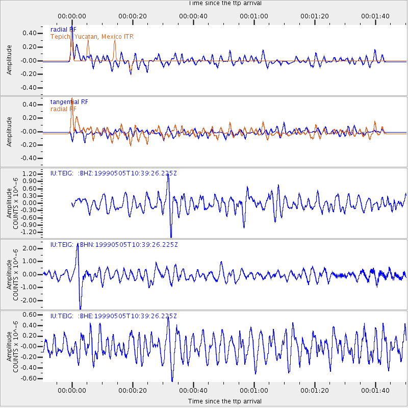
TEIG Tepich, Yucatan, Mexico - Earthquake Result Viewer
*The percent match for this event was below the threshold and hence no stack was calculated.
| Earthquake location: |
Kenai Peninsula, Alaska |
| Earthquake latitude/longitude: |
59.3/-151.5 |
| Earthquake time(UTC): |
1999/05/05 (125) 10:30:03 GMT |
| Earthquake Depth: |
71 km |
| Earthquake Magnitude: |
5.4 MB, 5.8 MW, 5.8 MW |
| Earthquake Catalog/Contributor: |
WHDF/NEIC |
|
| Network: |
IU Global Seismograph Network (GSN - IRIS/USGS) |
| Station: |
TEIG Tepich, Yucatan, Mexico |
| Lat/Lon: |
20.23 N/88.28 W |
| Elevation: |
69 m |
|
| Distance: |
59.2 deg |
| Az: |
102.534 deg |
| Baz: |
327.759 deg |
| Ray Param: |
$rayparam |
*The percent match for this event was below the threshold and hence was not used in the summary stack. |
|
| Radial Match: |
62.141674 % |
| Radial Bump: |
400 |
| Transverse Match: |
58.106255 % |
| Transverse Bump: |
400 |
| SOD ConfigId: |
4480 |
| Insert Time: |
2010-03-04 20:42:18.634 +0000 |
| GWidth: |
2.5 |
| Max Bumps: |
400 |
| Tol: |
0.001 |
|
Signal To Noise
| Channel | StoN | STA | LTA |
| IU:TEIG: :BHN:19990505T10:39:26.225Z | 5.8117824 | 1.2125278E-6 | 2.0863268E-7 |
| IU:TEIG: :BHE:19990505T10:39:26.225Z | 0.7802696 | 1.6060643E-7 | 2.0583454E-7 |
| IU:TEIG: :BHZ:19990505T10:39:26.225Z | 2.4644167 | 5.913922E-7 | 2.3997248E-7 |
| Arrivals |
| Ps | |
| PpPs | |
| PsPs/PpSs | |


