You are here: Home > Network List > IU - Global Seismograph Network (GSN - IRIS/USGS) Stations List
> Station TEIG Tepich, Yucatan, Mexico > Earthquake Result Viewer
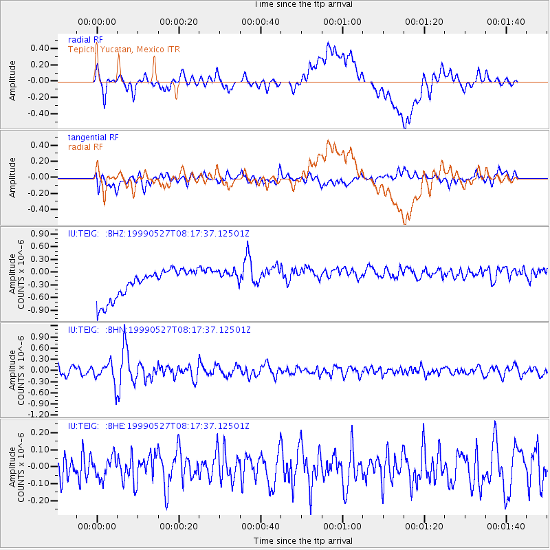
TEIG Tepich, Yucatan, Mexico - Earthquake Result Viewer
*The percent match for this event was below the threshold and hence no stack was calculated.
| Earthquake location: |
Southeastern Alaska |
| Earthquake latitude/longitude: |
58.7/-137.2 |
| Earthquake time(UTC): |
1999/05/27 (147) 08:08:58 GMT |
| Earthquake Depth: |
10 km |
| Earthquake Magnitude: |
5.5 MB, 5.2 MS, 5.8 MW, 5.4 ML |
| Earthquake Catalog/Contributor: |
WHDF/NEIC |
|
| Network: |
IU Global Seismograph Network (GSN - IRIS/USGS) |
| Station: |
TEIG Tepich, Yucatan, Mexico |
| Lat/Lon: |
20.23 N/88.28 W |
| Elevation: |
69 m |
|
| Distance: |
52.0 deg |
| Az: |
116.086 deg |
| Baz: |
330.001 deg |
| Ray Param: |
$rayparam |
*The percent match for this event was below the threshold and hence was not used in the summary stack. |
|
| Radial Match: |
28.995722 % |
| Radial Bump: |
400 |
| Transverse Match: |
48.14525 % |
| Transverse Bump: |
400 |
| SOD ConfigId: |
4480 |
| Insert Time: |
2010-03-04 20:42:20.772 +0000 |
| GWidth: |
2.5 |
| Max Bumps: |
400 |
| Tol: |
0.001 |
|
Signal To Noise
| Channel | StoN | STA | LTA |
| IU:TEIG: :BHN:19990527T08:17:37.12501Z | 2.5666492 | 2.8172494E-7 | 1.0976371E-7 |
| IU:TEIG: :BHE:19990527T08:17:37.12501Z | 0.751039 | 6.387348E-8 | 8.504682E-8 |
| IU:TEIG: :BHZ:19990527T08:17:37.12501Z | 0.7034076 | 2.3528835E-7 | 3.3449788E-7 |
| Arrivals |
| Ps | |
| PpPs | |
| PsPs/PpSs | |


