You are here: Home > Network List > IU - Global Seismograph Network (GSN - IRIS/USGS) Stations List
> Station TEIG Tepich, Yucatan, Mexico > Earthquake Result Viewer
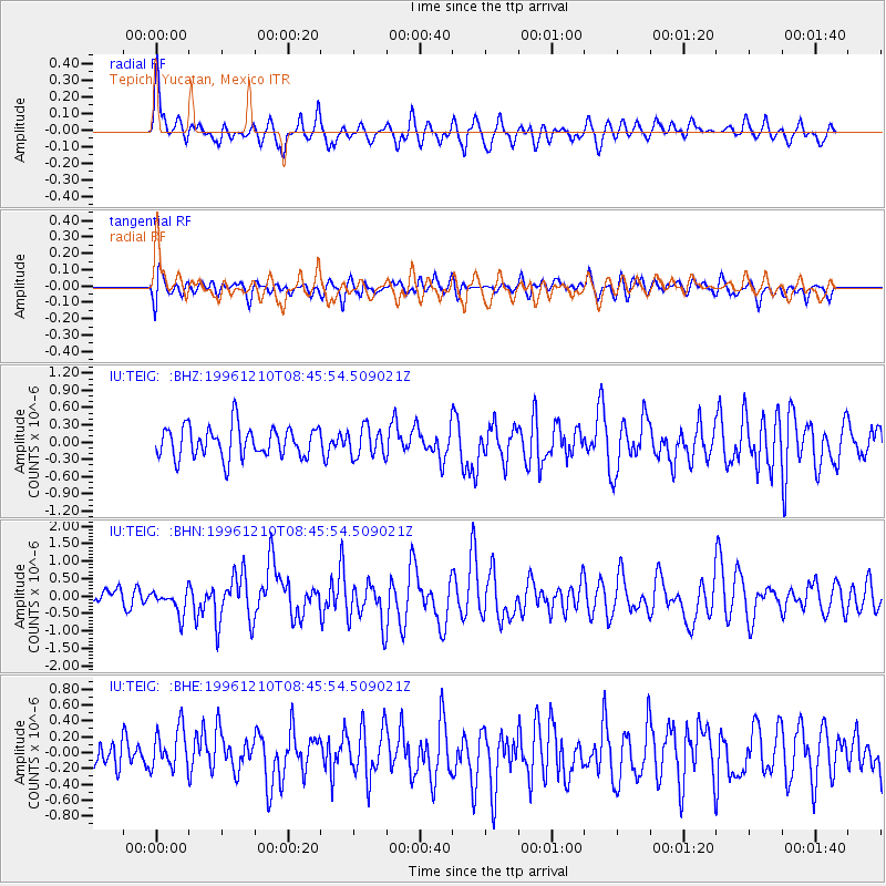
TEIG Tepich, Yucatan, Mexico - Earthquake Result Viewer
*The percent match for this event was below the threshold and hence no stack was calculated.
| Earthquake location: |
Central Mid-Atlantic Ridge |
| Earthquake latitude/longitude: |
0.9/-30.0 |
| Earthquake time(UTC): |
1996/12/10 (345) 08:36:18 GMT |
| Earthquake Depth: |
10 km |
| Earthquake Magnitude: |
6.0 MB, 6.2 MS, 6.6 UNKNOWN, 6.6 MW |
| Earthquake Catalog/Contributor: |
WHDF/NEIC |
|
| Network: |
IU Global Seismograph Network (GSN - IRIS/USGS) |
| Station: |
TEIG Tepich, Yucatan, Mexico |
| Lat/Lon: |
20.23 N/88.28 W |
| Elevation: |
69 m |
|
| Distance: |
60.0 deg |
| Az: |
292.834 deg |
| Baz: |
101.096 deg |
| Ray Param: |
$rayparam |
*The percent match for this event was below the threshold and hence was not used in the summary stack. |
|
| Radial Match: |
59.075 % |
| Radial Bump: |
400 |
| Transverse Match: |
60.381546 % |
| Transverse Bump: |
400 |
| SOD ConfigId: |
4480 |
| Insert Time: |
2010-03-04 20:42:24.998 +0000 |
| GWidth: |
2.5 |
| Max Bumps: |
400 |
| Tol: |
0.001 |
|
Signal To Noise
| Channel | StoN | STA | LTA |
| IU:TEIG: :BHN:19961210T08:45:54.509021Z | 1.6103188 | 3.5166659E-7 | 2.183832E-7 |
| IU:TEIG: :BHE:19961210T08:45:54.509021Z | 1.2364255 | 2.8412165E-7 | 2.2979276E-7 |
| IU:TEIG: :BHZ:19961210T08:45:54.509021Z | 0.95993674 | 2.5655052E-7 | 2.6725775E-7 |
| Arrivals |
| Ps | |
| PpPs | |
| PsPs/PpSs | |


