You are here: Home > Network List > UW - Pacific Northwest Regional Seismic Network Stations List
> Station BLOW Detroit Lake, OR, USA > Earthquake Result Viewer
BLOW Detroit Lake, OR, USA - Earthquake Result Viewer
| Earthquake location: |
Near Coast Of Central Chile |
| Earthquake latitude/longitude: |
-30.8/-71.4 |
| Earthquake time(UTC): |
2015/09/26 (269) 02:51:18 GMT |
| Earthquake Depth: |
38 km |
| Earthquake Magnitude: |
6.2 MO |
| Earthquake Catalog/Contributor: |
NEIC PDE/NEIC ALERT |
|
| Network: |
UW Pacific Northwest Regional Seismic Network |
| Station: |
BLOW Detroit Lake, OR, USA |
| Lat/Lon: |
44.68 N/122.19 W |
| Elevation: |
652 m |
|
| Distance: |
88.2 deg |
| Az: |
326.422 deg |
| Baz: |
138.164 deg |
| Ray Param: |
0.04267493 |
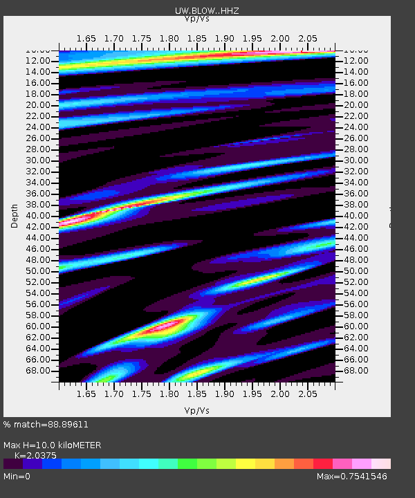
| Estimated Moho Depth: |
10.0 km |
| Estimated Crust Vp/Vs: |
2.04 |
| Assumed Crust Vp: |
6.566 km/s |
| Estimated Crust Vs: |
3.223 km/s |
| Estimated Crust Poisson's Ratio: |
0.34 |
|
| Radial Match: |
88.89611 % |
| Radial Bump: |
400 |
| Transverse Match: |
82.3372 % |
| Transverse Bump: |
400 |
| SOD ConfigId: |
7422571 |
| Insert Time: |
2019-04-21 00:46:08.033 +0000 |
| GWidth: |
2.5 |
| Max Bumps: |
400 |
| Tol: |
0.001 |
|

Signal To Noise
| Channel | StoN | STA | LTA |
| UW:BLOW: :HHZ:20150926T03:03:34.11803Z | 14.556432 | 2.1505855E-6 | 1.4774126E-7 |
| UW:BLOW: :HHN:20150926T03:03:34.11803Z | 4.0869417 | 4.9267095E-7 | 1.2054758E-7 |
| UW:BLOW: :HHE:20150926T03:03:34.11803Z | 3.9585083 | 5.334421E-7 | 1.3475837E-7 |
| Arrivals |
| Ps | 1.6 SECOND |
| PpPs | 4.5 SECOND |
| PsPs/PpSs | 6.1 SECOND |


