You are here: Home > Network List > UW - Pacific Northwest Regional Seismic Network Stations List
> Station LEBA Lebam, WA, USA > Earthquake Result Viewer
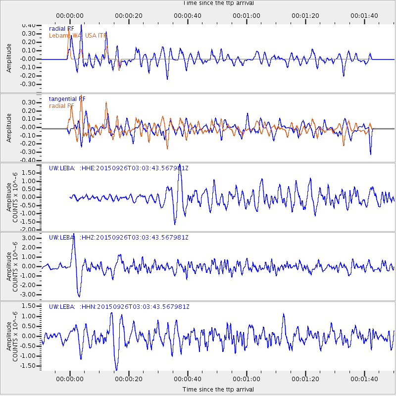
LEBA Lebam, WA, USA - Earthquake Result Viewer
*The percent match for this event was below the threshold and hence no stack was calculated.
| Earthquake location: |
Near Coast Of Central Chile |
| Earthquake latitude/longitude: |
-30.8/-71.4 |
| Earthquake time(UTC): |
2015/09/26 (269) 02:51:18 GMT |
| Earthquake Depth: |
38 km |
| Earthquake Magnitude: |
6.2 MO |
| Earthquake Catalog/Contributor: |
NEIC PDE/NEIC ALERT |
|
| Network: |
UW Pacific Northwest Regional Seismic Network |
| Station: |
LEBA Lebam, WA, USA |
| Lat/Lon: |
46.55 N/123.56 W |
| Elevation: |
73 m |
|
| Distance: |
90.3 deg |
| Az: |
326.961 deg |
| Baz: |
137.19 deg |
| Ray Param: |
$rayparam |
*The percent match for this event was below the threshold and hence was not used in the summary stack. |
|
| Radial Match: |
76.13794 % |
| Radial Bump: |
400 |
| Transverse Match: |
68.549446 % |
| Transverse Bump: |
400 |
| SOD ConfigId: |
7422571 |
| Insert Time: |
2019-04-21 00:46:17.995 +0000 |
| GWidth: |
2.5 |
| Max Bumps: |
400 |
| Tol: |
0.001 |
|
Signal To Noise
| Channel | StoN | STA | LTA |
| UW:LEBA: :HHZ:20150926T03:03:43.567981Z | 10.378448 | 1.8100887E-6 | 1.7440844E-7 |
| UW:LEBA: :HHN:20150926T03:03:43.567981Z | 2.855703 | 4.8004017E-7 | 1.6809877E-7 |
| UW:LEBA: :HHE:20150926T03:03:43.567981Z | 3.6879544 | 4.299171E-7 | 1.1657332E-7 |
| Arrivals |
| Ps | |
| PpPs | |
| PsPs/PpSs | |


