You are here: Home > Network List > UW - Pacific Northwest Regional Seismic Network Stations List
> Station MRBL Marblemount, WA, USA > Earthquake Result Viewer
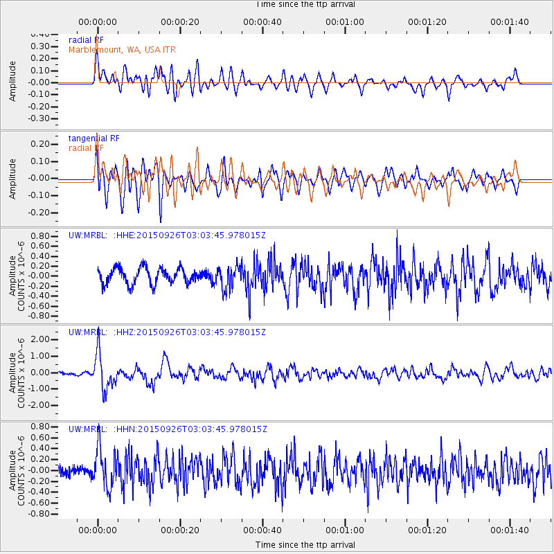
MRBL Marblemount, WA, USA - Earthquake Result Viewer
*The percent match for this event was below the threshold and hence no stack was calculated.
| Earthquake location: |
Near Coast Of Central Chile |
| Earthquake latitude/longitude: |
-30.8/-71.4 |
| Earthquake time(UTC): |
2015/09/26 (269) 02:51:18 GMT |
| Earthquake Depth: |
38 km |
| Earthquake Magnitude: |
6.2 MO |
| Earthquake Catalog/Contributor: |
NEIC PDE/NEIC ALERT |
|
| Network: |
UW Pacific Northwest Regional Seismic Network |
| Station: |
MRBL Marblemount, WA, USA |
| Lat/Lon: |
48.52 N/121.48 W |
| Elevation: |
75 m |
|
| Distance: |
90.8 deg |
| Az: |
329.329 deg |
| Baz: |
138.697 deg |
| Ray Param: |
$rayparam |
*The percent match for this event was below the threshold and hence was not used in the summary stack. |
|
| Radial Match: |
72.29825 % |
| Radial Bump: |
400 |
| Transverse Match: |
81.65389 % |
| Transverse Bump: |
400 |
| SOD ConfigId: |
7422571 |
| Insert Time: |
2019-04-21 00:46:19.777 +0000 |
| GWidth: |
2.5 |
| Max Bumps: |
400 |
| Tol: |
0.001 |
|
Signal To Noise
| Channel | StoN | STA | LTA |
| UW:MRBL: :HHZ:20150926T03:03:45.978015Z | 12.238735 | 1.1390721E-6 | 9.3071066E-8 |
| UW:MRBL: :HHN:20150926T03:03:45.978015Z | 3.1744123 | 3.7842187E-7 | 1.1921006E-7 |
| UW:MRBL: :HHE:20150926T03:03:45.978015Z | 1.4618424 | 2.3090215E-7 | 1.5795283E-7 |
| Arrivals |
| Ps | |
| PpPs | |
| PsPs/PpSs | |


