You are here: Home > Network List > UW - Pacific Northwest Regional Seismic Network Stations List
> Station PASS Maple Falls, WA, USA > Earthquake Result Viewer
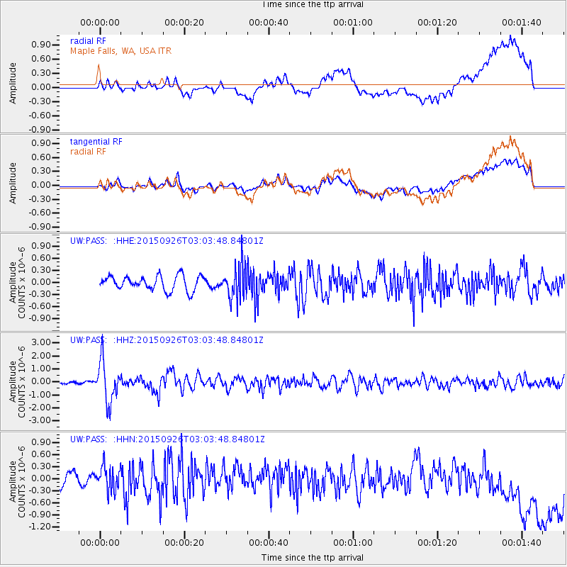
PASS Maple Falls, WA, USA - Earthquake Result Viewer
*The percent match for this event was below the threshold and hence no stack was calculated.
| Earthquake location: |
Near Coast Of Central Chile |
| Earthquake latitude/longitude: |
-30.8/-71.4 |
| Earthquake time(UTC): |
2015/09/26 (269) 02:51:18 GMT |
| Earthquake Depth: |
38 km |
| Earthquake Magnitude: |
6.2 MO |
| Earthquake Catalog/Contributor: |
NEIC PDE/NEIC ALERT |
|
| Network: |
UW Pacific Northwest Regional Seismic Network |
| Station: |
PASS Maple Falls, WA, USA |
| Lat/Lon: |
49.00 N/122.09 W |
| Elevation: |
174 m |
|
| Distance: |
91.4 deg |
| Az: |
329.35 deg |
| Baz: |
138.246 deg |
| Ray Param: |
$rayparam |
*The percent match for this event was below the threshold and hence was not used in the summary stack. |
|
| Radial Match: |
65.25102 % |
| Radial Bump: |
400 |
| Transverse Match: |
57.118286 % |
| Transverse Bump: |
400 |
| SOD ConfigId: |
7422571 |
| Insert Time: |
2019-04-21 00:46:21.747 +0000 |
| GWidth: |
2.5 |
| Max Bumps: |
400 |
| Tol: |
0.001 |
|
Signal To Noise
| Channel | StoN | STA | LTA |
| UW:PASS: :HHZ:20150926T03:03:48.84801Z | 13.10332 | 1.602658E-6 | 1.2230932E-7 |
| UW:PASS: :HHN:20150926T03:03:48.84801Z | 1.9826373 | 2.9980993E-7 | 1.5121773E-7 |
| UW:PASS: :HHE:20150926T03:03:48.84801Z | 2.4263482 | 4.3214064E-7 | 1.781033E-7 |
| Arrivals |
| Ps | |
| PpPs | |
| PsPs/PpSs | |


