You are here: Home > Network List > IW - Intermountain West Stations List
> Station MFID Camas Ranch, Mayfield, ID, USA > Earthquake Result Viewer
MFID Camas Ranch, Mayfield, ID, USA - Earthquake Result Viewer
| Earthquake location: |
Solomon Islands |
| Earthquake latitude/longitude: |
-11.1/163.7 |
| Earthquake time(UTC): |
2015/05/22 (142) 21:45:18 GMT |
| Earthquake Depth: |
7.9 km |
| Earthquake Magnitude: |
6.8 MO |
| Earthquake Catalog/Contributor: |
NEIC PDE/NEIC ALERT |
|
| Network: |
IW Intermountain West |
| Station: |
MFID Camas Ranch, Mayfield, ID, USA |
| Lat/Lon: |
43.42 N/115.83 W |
| Elevation: |
1302 m |
|
| Distance: |
90.7 deg |
| Az: |
45.95 deg |
| Baz: |
255.503 deg |
| Ray Param: |
0.04165333 |
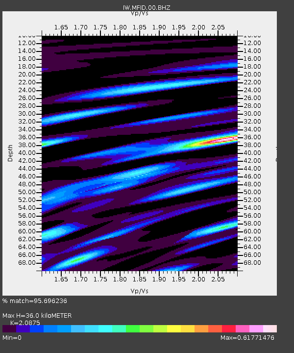
| Estimated Moho Depth: |
36.0 km |
| Estimated Crust Vp/Vs: |
2.09 |
| Assumed Crust Vp: |
6.291 km/s |
| Estimated Crust Vs: |
3.014 km/s |
| Estimated Crust Poisson's Ratio: |
0.35 |
|
| Radial Match: |
95.696236 % |
| Radial Bump: |
400 |
| Transverse Match: |
78.18473 % |
| Transverse Bump: |
400 |
| SOD ConfigId: |
976571 |
| Insert Time: |
2015-06-05 22:31:11.187 +0000 |
| GWidth: |
2.5 |
| Max Bumps: |
400 |
| Tol: |
0.001 |
|

Signal To Noise
| Channel | StoN | STA | LTA |
| IW:MFID:00:BHZ:20150522T21:57:50.423999Z | 7.809571 | 4.6698383E-7 | 5.979635E-8 |
| IW:MFID:00:BH1:20150522T21:57:50.423999Z | 2.2716525 | 1.039857E-7 | 4.5775355E-8 |
| IW:MFID:00:BH2:20150522T21:57:50.423999Z | 3.4235997 | 1.762345E-7 | 5.147637E-8 |
| Arrivals |
| Ps | 6.3 SECOND |
| PpPs | 17 SECOND |
| PsPs/PpSs | 24 SECOND |


