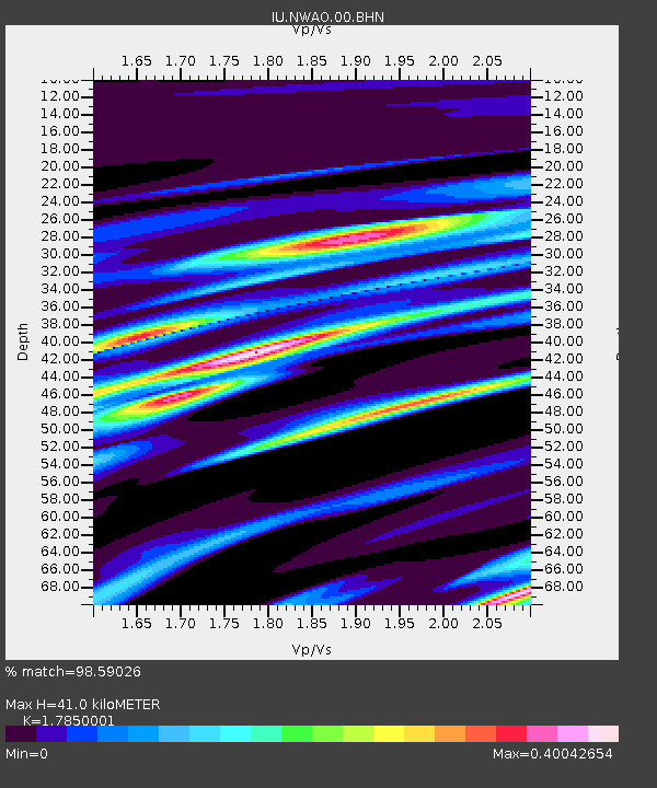
NWAO Narrogin, Australia - Earthquake Result Viewer

Earthquake location: New Ireland Region, P.N.G.
Earthquake latitude/longitude: -4.0/152.2
Earthquake time(UTC): 2000/11/16 (321) 04:54:56 GMT
Earthquake Depth: 33 km
Earthquake Magnitude: 6.0 MB, 8.2 MS, 8.0 MW, 8.0 ME
Earthquake Catalog/Contributor: WHDF/NEIC
Network: IU Global Seismograph Network (GSN - IRIS/USGS)
Station: NWAO Narrogin, Australia
Lat/Lon: 32.93 S/117.23 E
Elevation: 265 m
Distance: 43.5 deg
Az: 224.379 deg
Baz: 56.061 deg
Ray Param: 0.07243125
Estimated Moho Depth: 41.0 km
Estimated Crust Vp/Vs: 1.79
Assumed Crust Vp: 6.419 km/s
Estimated Crust Vs: 3.596 km/s
Estimated Crust Poisson's Ratio: 0.27
Radial Match: 98.59026 %
Radial Bump: 189
Transverse Match: 86.95893 %
Transverse Bump: 400
SOD ConfigId: 3744
Insert Time: 2010-03-04 20:42:41.085 +0000
GWidth: 2.5
Max Bumps: 400
Tol: 0.001

Signal To Noise

ChannelStoNSTALTA
IU:NWAO:00:BHN:20001116T05:02:26.621989Z1.147423.269203E-72.849177E-7
IU:NWAO:00:BHE:20001116T05:02:26.621989Z0.45271681.7847194E-73.9422423E-7
IU:NWAO:00:BHZ:20001116T05:02:26.621989Z0.891762553.8349654E-74.3004331E-7
Arrivals
Ps5.4 SECOND
PpPs17 SECOND
PsPs/PpSs22 SECOND