You are here: Home > Network List > XD14 - Illuminating the architecture of the greater Mount St. Helens magmatic systems f Stations List
> Station ML09 "Mount St Helens, WA" > Earthquake Result Viewer
ML09 "Mount St Helens, WA" - Earthquake Result Viewer
| Earthquake location: |
Near Coast Of Central Chile |
| Earthquake latitude/longitude: |
-30.8/-71.4 |
| Earthquake time(UTC): |
2015/09/26 (269) 02:51:18 GMT |
| Earthquake Depth: |
38 km |
| Earthquake Magnitude: |
6.2 MO |
| Earthquake Catalog/Contributor: |
NEIC PDE/NEIC ALERT |
|
| Network: |
XD Illuminating the architecture of the greater Mount St. Helens magmatic systems f |
| Station: |
ML09 "Mount St Helens, WA" |
| Lat/Lon: |
46.08 N/121.88 W |
| Elevation: |
1144 m |
|
| Distance: |
89.1 deg |
| Az: |
327.511 deg |
| Baz: |
138.406 deg |
| Ray Param: |
0.0420123 |
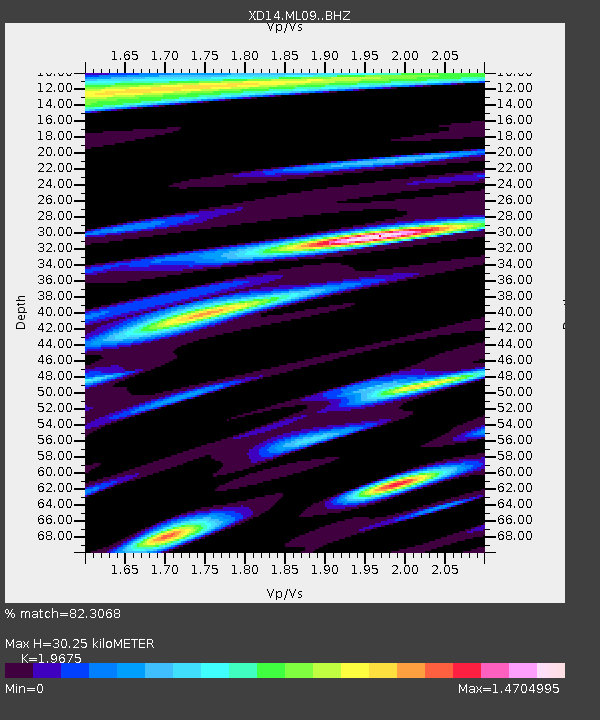
| Estimated Moho Depth: |
30.25 km |
| Estimated Crust Vp/Vs: |
1.97 |
| Assumed Crust Vp: |
6.597 km/s |
| Estimated Crust Vs: |
3.353 km/s |
| Estimated Crust Poisson's Ratio: |
0.33 |
|
| Radial Match: |
82.3068 % |
| Radial Bump: |
400 |
| Transverse Match: |
75.84047 % |
| Transverse Bump: |
400 |
| SOD ConfigId: |
7422571 |
| Insert Time: |
2019-04-21 00:47:36.869 +0000 |
| GWidth: |
2.5 |
| Max Bumps: |
400 |
| Tol: |
0.001 |
|

Signal To Noise
| Channel | StoN | STA | LTA |
| XD:ML09: :BHZ:20150926T03:03:38.325Z | 18.584322 | 3.4274497E-6 | 1.8442694E-7 |
| XD:ML09: :BHN:20150926T03:03:38.325Z | 2.8834262 | 1.0699532E-6 | 3.710701E-7 |
| XD:ML09: :BHE:20150926T03:03:38.325Z | 7.1030736 | 1.1049732E-6 | 1.5556269E-7 |
| Arrivals |
| Ps | 4.5 SECOND |
| PpPs | 13 SECOND |
| PsPs/PpSs | 18 SECOND |


