You are here: Home > Network List > IU - Global Seismograph Network (GSN - IRIS/USGS) Stations List
> Station NWAO Narrogin, Australia > Earthquake Result Viewer
NWAO Narrogin, Australia - Earthquake Result Viewer

| Earthquake location: |
Sulawesi, Indonesia |
| Earthquake latitude/longitude: |
-1.1/123.6 |
| Earthquake time(UTC): |
2000/05/04 (125) 04:21:16 GMT |
| Earthquake Depth: |
26 km |
| Earthquake Magnitude: |
6.7 MB, 7.5 MS, 7.6 MW, 7.5 ME |
| Earthquake Catalog/Contributor: |
WHDF/NEIC |
|
| Network: |
IU Global Seismograph Network (GSN - IRIS/USGS) |
| Station: |
NWAO Narrogin, Australia |
| Lat/Lon: |
32.93 S/117.23 E |
| Elevation: |
265 m |
|
| Distance: |
32.2 deg |
| Az: |
190.034 deg |
| Baz: |
11.954 deg |
| Ray Param: |
0.078714885 |
| Estimated Moho Depth: |
36.0 km |
| Estimated Crust Vp/Vs: |
1.83 |
| Assumed Crust Vp: |
6.419 km/s |
| Estimated Crust Vs: |
3.503 km/s |
| Estimated Crust Poisson's Ratio: |
0.29 |
|
| Radial Match: |
96.22843 % |
| Radial Bump: |
180 |
| Transverse Match: |
85.530815 % |
| Transverse Bump: |
400 |
| SOD ConfigId: |
3744 |
| Insert Time: |
2010-03-04 20:42:45.724 +0000 |
| GWidth: |
2.5 |
| Max Bumps: |
400 |
| Tol: |
0.001 |
|
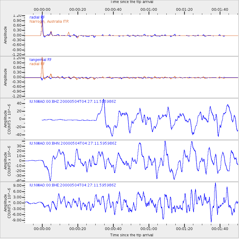
Signal To Noise
| Channel | StoN | STA | LTA |
| IU:NWAO:00:BHN:20000504T04:27:11.595986Z | 40.52167 | 1.801341E-5 | 4.445377E-7 |
| IU:NWAO:00:BHE:20000504T04:27:11.595986Z | 5.4422 | 1.8246682E-6 | 3.3528136E-7 |
| IU:NWAO:00:BHZ:20000504T04:27:11.595986Z | 32.37348 | 2.4512578E-5 | 7.571807E-7 |
| Arrivals |
| Ps | 5.0 SECOND |
| PpPs | 15 SECOND |
| PsPs/PpSs | 20 SECOND |


