You are here: Home > Network List > IU - Global Seismograph Network (GSN - IRIS/USGS) Stations List
> Station NWAO Narrogin, Australia > Earthquake Result Viewer
NWAO Narrogin, Australia - Earthquake Result Viewer
| Earthquake location: |
Kuril Islands |
| Earthquake latitude/longitude: |
43.0/146.8 |
| Earthquake time(UTC): |
2000/01/28 (028) 14:21:07 GMT |
| Earthquake Depth: |
61 km |
| Earthquake Magnitude: |
6.7 MB, 6.6 MS, 6.8 MW, 6.8 ME |
| Earthquake Catalog/Contributor: |
WHDF/NEIC |
|
| Network: |
IU Global Seismograph Network (GSN - IRIS/USGS) |
| Station: |
NWAO Narrogin, Australia |
| Lat/Lon: |
32.93 S/117.23 E |
| Elevation: |
265 m |
|
| Distance: |
80.3 deg |
| Az: |
204.927 deg |
| Baz: |
21.554 deg |
| Ray Param: |
0.048238542 |
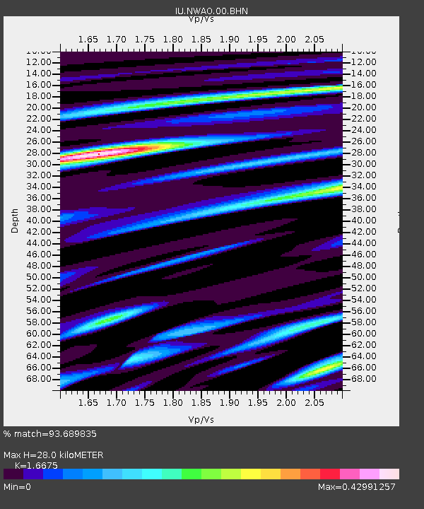
| Estimated Moho Depth: |
28.0 km |
| Estimated Crust Vp/Vs: |
1.67 |
| Assumed Crust Vp: |
6.419 km/s |
| Estimated Crust Vs: |
3.85 km/s |
| Estimated Crust Poisson's Ratio: |
0.22 |
|
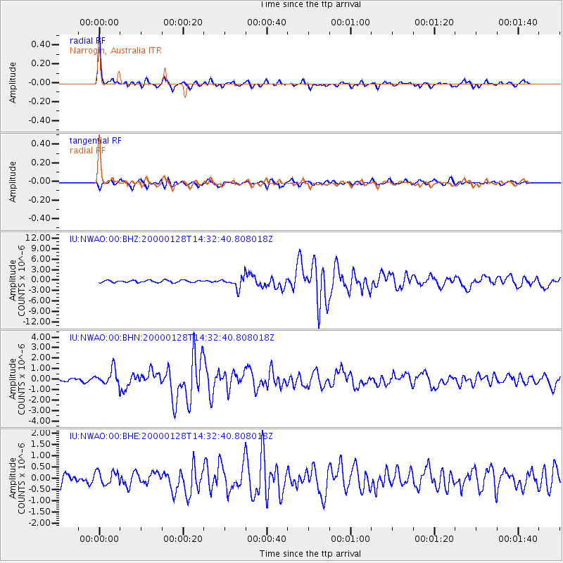
| Radial Match: |
93.689835 % |
| Radial Bump: |
252 |
| Transverse Match: |
81.19795 % |
| Transverse Bump: |
400 |
| SOD ConfigId: |
3744 |
| Insert Time: |
2010-03-04 20:42:59.577 +0000 |
| GWidth: |
2.5 |
| Max Bumps: |
400 |
| Tol: |
0.001 |
|
Signal To Noise
| Channel | StoN | STA | LTA |
| IU:NWAO:00:BHN:20000128T14:32:40.808018Z | 4.3872313 | 7.678616E-7 | 1.7502191E-7 |
| IU:NWAO:00:BHE:20000128T14:32:40.808018Z | 1.4753591 | 3.001557E-7 | 2.0344588E-7 |
| IU:NWAO:00:BHZ:20000128T14:32:40.808018Z | 5.380524 | 1.6488423E-6 | 3.064464E-7 |
| Arrivals |
| Ps | 3.0 SECOND |
| PpPs | 11 SECOND |
| PsPs/PpSs | 14 SECOND |


