You are here: Home > Network List > IU - Global Seismograph Network (GSN - IRIS/USGS) Stations List
> Station NWAO Narrogin, Australia > Earthquake Result Viewer
NWAO Narrogin, Australia - Earthquake Result Viewer
| Earthquake location: |
Celebes Sea |
| Earthquake latitude/longitude: |
5.4/121.9 |
| Earthquake time(UTC): |
1999/03/04 (063) 08:52:01 GMT |
| Earthquake Depth: |
33 km |
| Earthquake Magnitude: |
6.4 MB, 6.5 MS, 7.1 MW, 7.1 MW |
| Earthquake Catalog/Contributor: |
WHDF/NEIC |
|
| Network: |
IU Global Seismograph Network (GSN - IRIS/USGS) |
| Station: |
NWAO Narrogin, Australia |
| Lat/Lon: |
32.93 S/117.23 E |
| Elevation: |
265 m |
|
| Distance: |
38.4 deg |
| Az: |
186.379 deg |
| Baz: |
7.557 deg |
| Ray Param: |
0.07553532 |
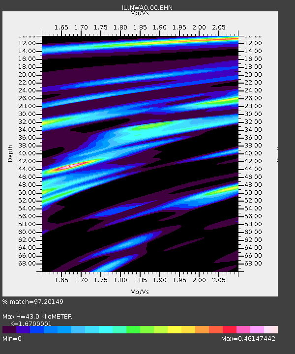
| Estimated Moho Depth: |
43.0 km |
| Estimated Crust Vp/Vs: |
1.67 |
| Assumed Crust Vp: |
6.419 km/s |
| Estimated Crust Vs: |
3.844 km/s |
| Estimated Crust Poisson's Ratio: |
0.22 |
|
| Radial Match: |
97.20149 % |
| Radial Bump: |
223 |
| Transverse Match: |
86.61068 % |
| Transverse Bump: |
400 |
| SOD ConfigId: |
4480 |
| Insert Time: |
2010-03-04 20:43:04.977 +0000 |
| GWidth: |
2.5 |
| Max Bumps: |
400 |
| Tol: |
0.001 |
|
Signal To Noise
| Channel | StoN | STA | LTA |
| IU:NWAO:00:BHN:19990304T08:58:49.534003Z | 20.707497 | 4.3803557E-6 | 2.1153477E-7 |
| IU:NWAO:00:BHE:19990304T08:58:49.534003Z | 17.01238 | 3.259526E-6 | 1.915973E-7 |
| IU:NWAO:00:BHZ:19990304T08:58:49.534003Z | 0.94475937 | 1.9322765E-7 | 2.0452578E-7 |
| Arrivals |
| Ps | 4.8 SECOND |
| PpPs | 17 SECOND |
| PsPs/PpSs | 21 SECOND |


