You are here: Home > Network List > IU - Global Seismograph Network (GSN - IRIS/USGS) Stations List
> Station NWAO Narrogin, Australia > Earthquake Result Viewer
NWAO Narrogin, Australia - Earthquake Result Viewer
| Earthquake location: |
Western Honshu, Japan |
| Earthquake latitude/longitude: |
34.1/132.5 |
| Earthquake time(UTC): |
2001/03/24 (083) 06:27:53 GMT |
| Earthquake Depth: |
50 km |
| Earthquake Magnitude: |
6.4 MB, 6.5 MS, 6.8 MW, 6.4 ME |
| Earthquake Catalog/Contributor: |
WHDF/NEIC |
|
| Network: |
IU Global Seismograph Network (GSN - IRIS/USGS) |
| Station: |
NWAO Narrogin, Australia |
| Lat/Lon: |
32.93 S/117.23 E |
| Elevation: |
265 m |
|
| Distance: |
68.2 deg |
| Az: |
193.823 deg |
| Baz: |
13.638 deg |
| Ray Param: |
0.056365266 |
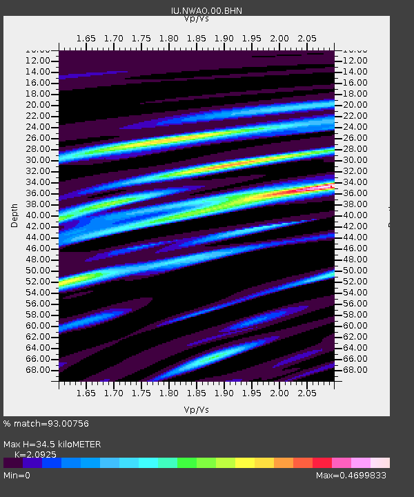
| Estimated Moho Depth: |
34.5 km |
| Estimated Crust Vp/Vs: |
2.09 |
| Assumed Crust Vp: |
6.419 km/s |
| Estimated Crust Vs: |
3.068 km/s |
| Estimated Crust Poisson's Ratio: |
0.35 |
|
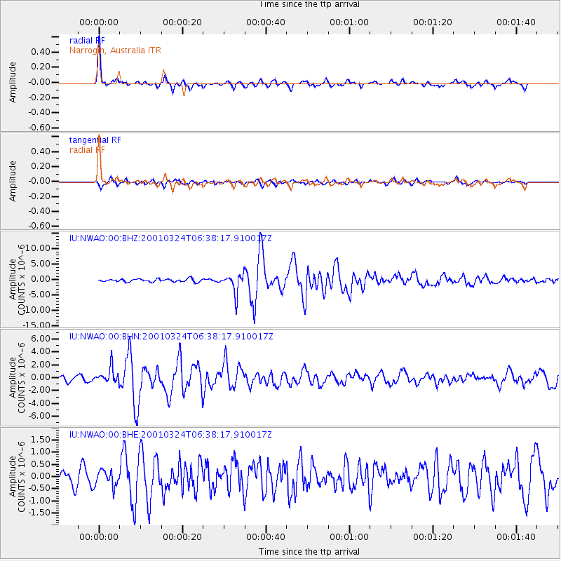
| Radial Match: |
93.00756 % |
| Radial Bump: |
379 |
| Transverse Match: |
86.06447 % |
| Transverse Bump: |
400 |
| SOD ConfigId: |
4714 |
| Insert Time: |
2010-03-04 20:43:17.232 +0000 |
| GWidth: |
2.5 |
| Max Bumps: |
400 |
| Tol: |
0.001 |
|
Signal To Noise
| Channel | StoN | STA | LTA |
| IU:NWAO:00:BHN:20010324T06:38:17.910017Z | 3.8825321 | 1.2320079E-6 | 3.173207E-7 |
| IU:NWAO:00:BHE:20010324T06:38:17.910017Z | 1.0548499 | 3.1954005E-7 | 3.0292466E-7 |
| IU:NWAO:00:BHZ:20010324T06:38:17.910017Z | 6.8306117 | 3.1839384E-6 | 4.6612783E-7 |
| Arrivals |
| Ps | 6.1 SECOND |
| PpPs | 16 SECOND |
| PsPs/PpSs | 22 SECOND |


