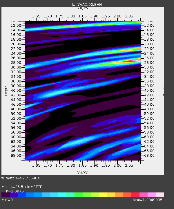
NWAO Narrogin, Australia - Earthquake Result Viewer

Earthquake location: Aru Islands Region, Indonesia
Earthquake latitude/longitude: -5.2/132.4
Earthquake time(UTC): 2001/04/04 (094) 07:44:11 GMT
Earthquake Depth: 33 km
Earthquake Magnitude: 5.9 MB, 6.0 MS, 6.4 MW, 6.4 MW
Earthquake Catalog/Contributor: WHDF/NEIC
Network: IU Global Seismograph Network (GSN - IRIS/USGS)
Station: NWAO Narrogin, Australia
Lat/Lon: 32.93 S/117.23 E
Elevation: 265 m
Distance: 31.0 deg
Az: 205.229 deg
Baz: 30.316 deg
Ray Param: 0.07915062
Estimated Moho Depth: 26.5 km
Estimated Crust Vp/Vs: 2.10
Assumed Crust Vp: 6.419 km/s
Estimated Crust Vs: 3.06 km/s
Estimated Crust Poisson's Ratio: 0.35
Radial Match: 92.736404 %
Radial Bump: 282
Transverse Match: 55.812225 %
Transverse Bump: 400
SOD ConfigId: 4714
Insert Time: 2010-03-04 20:43:31.536 +0000
GWidth: 2.5
Max Bumps: 400
Tol: 0.001

Signal To Noise

ChannelStoNSTALTA
IU:NWAO:00:BHN:20010404T07:49:55.409015Z3.89205079.998168E-72.568869E-7
IU:NWAO:00:BHE:20010404T07:49:55.409015Z1.525184.932647E-73.2341407E-7
IU:NWAO:00:BHZ:20010404T07:49:55.409015Z4.20950031.5169923E-63.603735E-7
Arrivals
Ps4.8 SECOND
PpPs12 SECOND
PsPs/PpSs17 SECOND