You are here: Home > Network List > IU - Global Seismograph Network (GSN - IRIS/USGS) Stations List
> Station NWAO Narrogin, Australia > Earthquake Result Viewer
NWAO Narrogin, Australia - Earthquake Result Viewer
| Earthquake location: |
Vanuatu Islands |
| Earthquake latitude/longitude: |
-15.1/167.4 |
| Earthquake time(UTC): |
1997/11/15 (319) 18:59:24 GMT |
| Earthquake Depth: |
123 km |
| Earthquake Magnitude: |
6.4 MB, 7.0 UNKNOWN, 6.8 ME |
| Earthquake Catalog/Contributor: |
WHDF/NEIC |
|
| Network: |
IU Global Seismograph Network (GSN - IRIS/USGS) |
| Station: |
NWAO Narrogin, Australia |
| Lat/Lon: |
32.93 S/117.23 E |
| Elevation: |
265 m |
|
| Distance: |
48.6 deg |
| Az: |
239.355 deg |
| Baz: |
81.071 deg |
| Ray Param: |
0.06880397 |
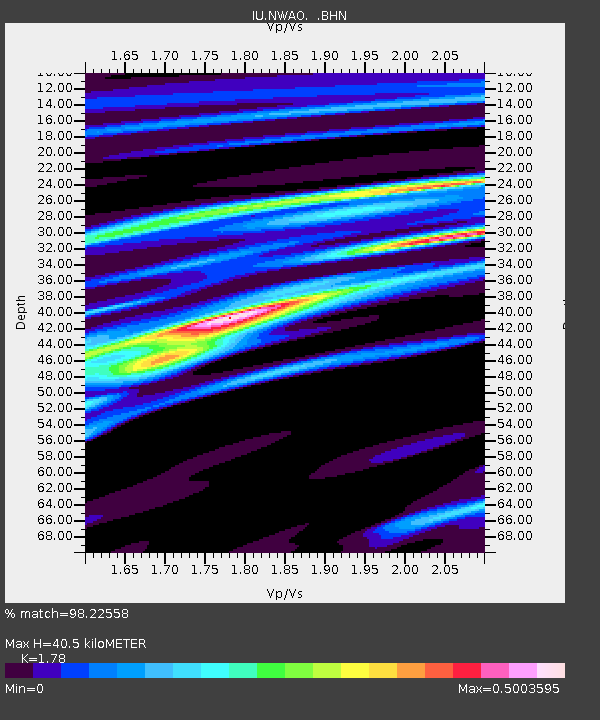
| Estimated Moho Depth: |
40.5 km |
| Estimated Crust Vp/Vs: |
1.78 |
| Assumed Crust Vp: |
6.419 km/s |
| Estimated Crust Vs: |
3.606 km/s |
| Estimated Crust Poisson's Ratio: |
0.27 |
|
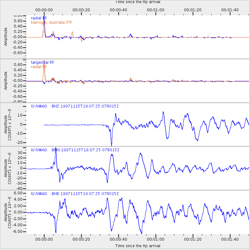
| Radial Match: |
98.22558 % |
| Radial Bump: |
203 |
| Transverse Match: |
96.13944 % |
| Transverse Bump: |
400 |
| SOD ConfigId: |
4480 |
| Insert Time: |
2010-03-04 20:43:44.254 +0000 |
| GWidth: |
2.5 |
| Max Bumps: |
400 |
| Tol: |
0.001 |
|
Signal To Noise
| Channel | StoN | STA | LTA |
| IU:NWAO: :BHN:19971115T19:07:25.078015Z | 7.5143423 | 1.8269232E-6 | 2.4312484E-7 |
| IU:NWAO: :BHE:19971115T19:07:25.078015Z | 2.322788 | 3.8555518E-7 | 1.659881E-7 |
| IU:NWAO: :BHZ:19971115T19:07:25.078015Z | 5.3964286 | 9.743477E-7 | 1.8055417E-7 |
| Arrivals |
| Ps | 5.2 SECOND |
| PpPs | 17 SECOND |
| PsPs/PpSs | 22 SECOND |


