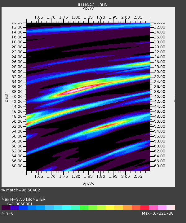
NWAO Narrogin, Australia - Earthquake Result Viewer
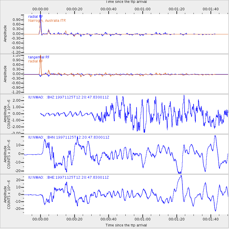
Earthquake location: Minahassa Peninsula, Sulawesi
Earthquake latitude/longitude: 1.2/122.5
Earthquake time(UTC): 1997/11/25 (329) 12:14:33 GMT
Earthquake Depth: 24 km
Earthquake Magnitude: 6.1 MB, 6.8 MS, 7.1 UNKNOWN, 6.7 ME
Earthquake Catalog/Contributor: WHDF/NEIC
Network: IU Global Seismograph Network (GSN - IRIS/USGS)
Station: NWAO Narrogin, Australia
Lat/Lon: 32.93 S/117.23 E
Elevation: 265 m
Distance: 34.4 deg
Az: 187.918 deg
Baz: 9.424 deg
Ray Param: 0.077752024
Estimated Moho Depth: 37.0 km
Estimated Crust Vp/Vs: 1.81
Assumed Crust Vp: 6.419 km/s
Estimated Crust Vs: 3.556 km/s
Estimated Crust Poisson's Ratio: 0.28
Radial Match: 96.50402 %
Radial Bump: 234
Transverse Match: 82.54882 %
Transverse Bump: 400
SOD ConfigId: 4480
Insert Time: 2010-03-04 20:43:46.834 +0000
GWidth: 2.5
Max Bumps: 400
Tol: 0.001

Signal To Noise

ChannelStoNSTALTA
IU:NWAO: :BHN:19971125T12:20:47.830011Z39.3421759.458897E-62.404264E-7
IU:NWAO: :BHE:19971125T12:20:47.830011Z31.422087.1013087E-62.2599743E-7
IU:NWAO: :BHZ:19971125T12:20:47.830011Z2.61627674.8341093E-71.8477056E-7
Arrivals
Ps5.0 SECOND
PpPs15 SECOND
PsPs/PpSs20 SECOND