You are here: Home > Network List > IU - Global Seismograph Network (GSN - IRIS/USGS) Stations List
> Station NWAO Narrogin, Australia > Earthquake Result Viewer
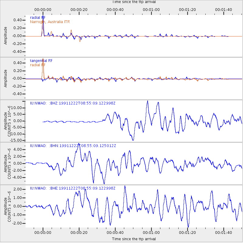
NWAO Narrogin, Australia - Earthquake Result Viewer

| Earthquake location: |
Kuril Islands |
| Earthquake latitude/longitude: |
45.5/151.0 |
| Earthquake time(UTC): |
1991/12/22 (356) 08:43:13 GMT |
| Earthquake Depth: |
26 km |
| Earthquake Magnitude: |
6.3 MB, 7.4 MS |
| Earthquake Catalog/Contributor: |
WHDF/NEIC |
|
| Network: |
IU Global Seismograph Network (GSN - IRIS/USGS) |
| Station: |
NWAO Narrogin, Australia |
| Lat/Lon: |
32.93 S/117.23 E |
| Elevation: |
265 m |
|
| Distance: |
83.8 deg |
| Az: |
208.083 deg |
| Baz: |
23.193 deg |
| Ray Param: |
0.04586897 |
| Estimated Moho Depth: |
34.75 km |
| Estimated Crust Vp/Vs: |
1.99 |
| Assumed Crust Vp: |
6.419 km/s |
| Estimated Crust Vs: |
3.234 km/s |
| Estimated Crust Poisson's Ratio: |
0.33 |
|
| Radial Match: |
98.31801 % |
| Radial Bump: |
245 |
| Transverse Match: |
92.945564 % |
| Transverse Bump: |
400 |
| SOD ConfigId: |
16938 |
| Insert Time: |
2010-03-04 20:44:05.631 +0000 |
| GWidth: |
2.5 |
| Max Bumps: |
400 |
| Tol: |
0.001 |
|
Signal To Noise
| Channel | StoN | STA | LTA |
| IU:NWAO: :BHN:19911222T08:55:09.125012Z | 2.4254522 | 4.3478786E-7 | 1.7926054E-7 |
| IU:NWAO: :BHE:19911222T08:55:09.122998Z | 0.8923921 | 1.4151868E-7 | 1.5858352E-7 |
| IU:NWAO: :BHZ:19911222T08:55:09.122998Z | 2.8020992 | 8.5384323E-7 | 3.0471557E-7 |
| Arrivals |
| Ps | 5.5 SECOND |
| PpPs | 16 SECOND |
| PsPs/PpSs | 21 SECOND |


