You are here: Home > Network List > IU - Global Seismograph Network (GSN - IRIS/USGS) Stations List
> Station NWAO Narrogin, Australia > Earthquake Result Viewer
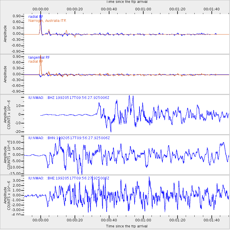
NWAO Narrogin, Australia - Earthquake Result Viewer

| Earthquake location: |
Mindanao, Philippines |
| Earthquake latitude/longitude: |
7.3/126.8 |
| Earthquake time(UTC): |
1992/05/17 (138) 09:49:18 GMT |
| Earthquake Depth: |
33 km |
| Earthquake Magnitude: |
6.2 MB, 7.1 MS |
| Earthquake Catalog/Contributor: |
WHDF/NEIC |
|
| Network: |
IU Global Seismograph Network (GSN - IRIS/USGS) |
| Station: |
NWAO Narrogin, Australia |
| Lat/Lon: |
32.93 S/117.23 E |
| Elevation: |
265 m |
|
| Distance: |
41.0 deg |
| Az: |
192.246 deg |
| Baz: |
14.49 deg |
| Ray Param: |
0.07401274 |
| Estimated Moho Depth: |
37.25 km |
| Estimated Crust Vp/Vs: |
1.79 |
| Assumed Crust Vp: |
6.419 km/s |
| Estimated Crust Vs: |
3.591 km/s |
| Estimated Crust Poisson's Ratio: |
0.27 |
|
| Radial Match: |
97.2304 % |
| Radial Bump: |
252 |
| Transverse Match: |
87.14479 % |
| Transverse Bump: |
400 |
| SOD ConfigId: |
16938 |
| Insert Time: |
2010-03-04 20:44:13.801 +0000 |
| GWidth: |
2.5 |
| Max Bumps: |
400 |
| Tol: |
0.001 |
|
Signal To Noise
| Channel | StoN | STA | LTA |
| IU:NWAO: :BHN:19920517T09:56:27.925006Z | 14.573545 | 3.667533E-6 | 2.5165687E-7 |
| IU:NWAO: :BHE:19920517T09:56:27.925006Z | 3.5703197 | 7.600326E-7 | 2.1287522E-7 |
| IU:NWAO: :BHZ:19920517T09:56:27.925006Z | 14.063541 | 5.3134017E-6 | 3.7781393E-7 |
| Arrivals |
| Ps | 4.9 SECOND |
| PpPs | 15 SECOND |
| PsPs/PpSs | 20 SECOND |


