You are here: Home > Network List > IU - Global Seismograph Network (GSN - IRIS/USGS) Stations List
> Station NWAO Narrogin, Australia > Earthquake Result Viewer
NWAO Narrogin, Australia - Earthquake Result Viewer

| Earthquake location: |
South Of Fiji Islands |
| Earthquake latitude/longitude: |
-22.3/-178.5 |
| Earthquake time(UTC): |
1992/07/11 (193) 10:44:20 GMT |
| Earthquake Depth: |
381 km |
| Earthquake Magnitude: |
6.2 MB |
| Earthquake Catalog/Contributor: |
WHDF/NEIC |
|
| Network: |
IU Global Seismograph Network (GSN - IRIS/USGS) |
| Station: |
NWAO Narrogin, Australia |
| Lat/Lon: |
32.93 S/117.23 E |
| Elevation: |
265 m |
|
| Distance: |
57.2 deg |
| Az: |
244.376 deg |
| Baz: |
96.799 deg |
| Ray Param: |
0.062266152 |
| Estimated Moho Depth: |
38.0 km |
| Estimated Crust Vp/Vs: |
1.80 |
| Assumed Crust Vp: |
6.419 km/s |
| Estimated Crust Vs: |
3.571 km/s |
| Estimated Crust Poisson's Ratio: |
0.28 |
|
| Radial Match: |
93.52007 % |
| Radial Bump: |
311 |
| Transverse Match: |
57.523624 % |
| Transverse Bump: |
400 |
| SOD ConfigId: |
16938 |
| Insert Time: |
2010-03-04 20:44:17.844 +0000 |
| GWidth: |
2.5 |
| Max Bumps: |
400 |
| Tol: |
0.001 |
|
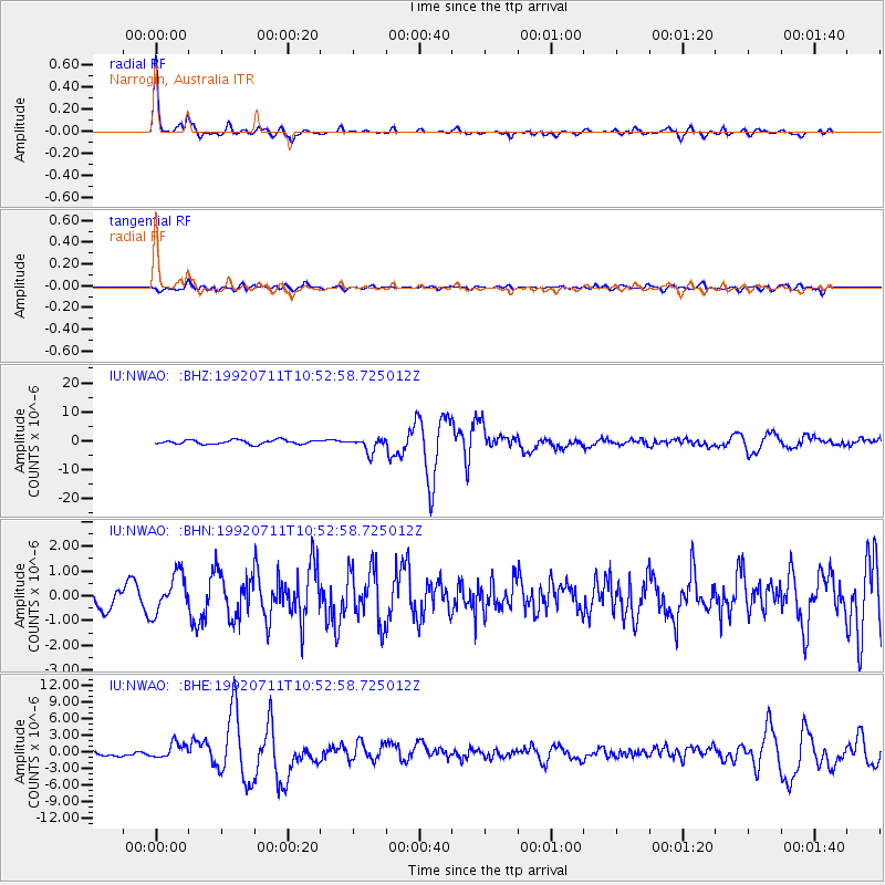
Signal To Noise
| Channel | StoN | STA | LTA |
| IU:NWAO: :BHN:19920711T10:52:58.725012Z | 1.7968588 | 7.838446E-7 | 4.362305E-7 |
| IU:NWAO: :BHE:19920711T10:52:58.725012Z | 4.343829 | 1.3953669E-6 | 3.212297E-7 |
| IU:NWAO: :BHZ:19920711T10:52:58.725012Z | 3.4707932 | 2.4718472E-6 | 7.121851E-7 |
| Arrivals |
| Ps | 4.9 SECOND |
| PpPs | 16 SECOND |
| PsPs/PpSs | 21 SECOND |


