You are here: Home > Network List > UU - University of Utah Regional Network Stations List
> Station MPU Maple Canyon, UT, USA > Earthquake Result Viewer
MPU Maple Canyon, UT, USA - Earthquake Result Viewer
| Earthquake location: |
Solomon Islands |
| Earthquake latitude/longitude: |
-11.1/163.7 |
| Earthquake time(UTC): |
2015/05/22 (142) 21:45:18 GMT |
| Earthquake Depth: |
7.9 km |
| Earthquake Magnitude: |
6.8 MO |
| Earthquake Catalog/Contributor: |
NEIC PDE/NEIC ALERT |
|
| Network: |
UU University of Utah Regional Network |
| Station: |
MPU Maple Canyon, UT, USA |
| Lat/Lon: |
40.02 N/111.63 W |
| Elevation: |
1909 m |
|
| Distance: |
93.0 deg |
| Az: |
49.973 deg |
| Baz: |
258.155 deg |
| Ray Param: |
0.041346505 |
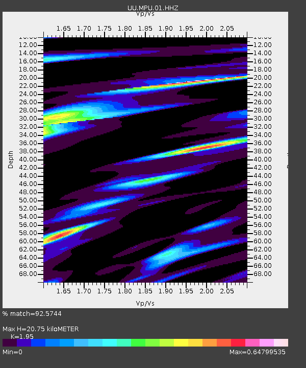
| Estimated Moho Depth: |
20.75 km |
| Estimated Crust Vp/Vs: |
1.95 |
| Assumed Crust Vp: |
6.155 km/s |
| Estimated Crust Vs: |
3.156 km/s |
| Estimated Crust Poisson's Ratio: |
0.32 |
|
| Radial Match: |
92.5744 % |
| Radial Bump: |
400 |
| Transverse Match: |
83.09372 % |
| Transverse Bump: |
400 |
| SOD ConfigId: |
976571 |
| Insert Time: |
2015-06-05 22:33:26.279 +0000 |
| GWidth: |
2.5 |
| Max Bumps: |
400 |
| Tol: |
0.001 |
|

Signal To Noise
| Channel | StoN | STA | LTA |
| UU:MPU:01:HHZ:20150522T21:58:00.958972Z | 3.5880766 | 8.069624E-9 | 2.249011E-9 |
| UU:MPU:01:HHN:20150522T21:58:00.958972Z | 0.31065452 | 8.5610957E-10 | 2.7558251E-9 |
| UU:MPU:01:HHE:20150522T21:58:00.958972Z | 1.8609574 | 3.9856918E-9 | 2.1417426E-9 |
| Arrivals |
| Ps | 3.3 SECOND |
| PpPs | 9.8 SECOND |
| PsPs/PpSs | 13 SECOND |


