You are here: Home > Network List > TA - USArray Transportable Network (new EarthScope stations) Stations List
> Station J20K Nowitna River, AK, USA > Earthquake Result Viewer
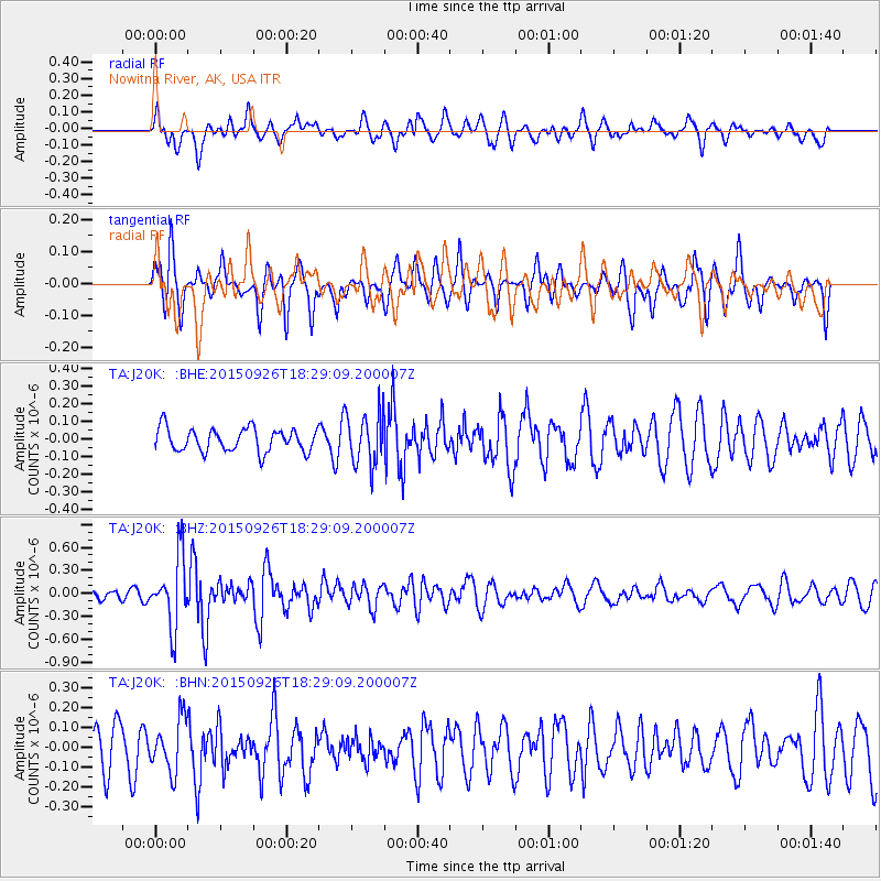
J20K Nowitna River, AK, USA - Earthquake Result Viewer
*The percent match for this event was below the threshold and hence no stack was calculated.
| Earthquake location: |
New Britain Region, P.N.G. |
| Earthquake latitude/longitude: |
-6.3/151.7 |
| Earthquake time(UTC): |
2015/09/26 (269) 18:17:24 GMT |
| Earthquake Depth: |
2.8 km |
| Earthquake Magnitude: |
5.5 MB |
| Earthquake Catalog/Contributor: |
NEIC PDE/NEIC COMCAT |
|
| Network: |
TA USArray Transportable Network (new EarthScope stations) |
| Station: |
J20K Nowitna River, AK, USA |
| Lat/Lon: |
64.18 N/154.15 W |
| Elevation: |
314 m |
|
| Distance: |
80.9 deg |
| Az: |
21.077 deg |
| Baz: |
234.712 deg |
| Ray Param: |
$rayparam |
*The percent match for this event was below the threshold and hence was not used in the summary stack. |
|
| Radial Match: |
63.44267 % |
| Radial Bump: |
400 |
| Transverse Match: |
49.23649 % |
| Transverse Bump: |
315 |
| SOD ConfigId: |
7422571 |
| Insert Time: |
2019-04-21 00:58:34.476 +0000 |
| GWidth: |
2.5 |
| Max Bumps: |
400 |
| Tol: |
0.001 |
|
Signal To Noise
| Channel | StoN | STA | LTA |
| TA:J20K: :BHZ:20150926T18:29:09.200007Z | 6.4041924 | 4.551761E-7 | 7.107471E-8 |
| TA:J20K: :BHN:20150926T18:29:09.200007Z | 1.3319024 | 1.3013408E-7 | 9.7705424E-8 |
| TA:J20K: :BHE:20150926T18:29:09.200007Z | 2.1811879 | 1.431031E-7 | 6.560787E-8 |
| Arrivals |
| Ps | |
| PpPs | |
| PsPs/PpSs | |


