You are here: Home > Network List > TA - USArray Transportable Network (new EarthScope stations) Stations List
> Station L04D Klamath Falls, OR, USA > Earthquake Result Viewer
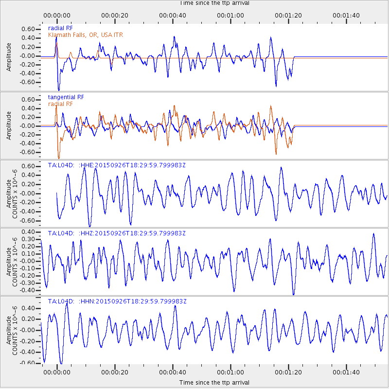
L04D Klamath Falls, OR, USA - Earthquake Result Viewer
*The percent match for this event was below the threshold and hence no stack was calculated.
| Earthquake location: |
New Britain Region, P.N.G. |
| Earthquake latitude/longitude: |
-6.3/151.7 |
| Earthquake time(UTC): |
2015/09/26 (269) 18:17:24 GMT |
| Earthquake Depth: |
2.8 km |
| Earthquake Magnitude: |
5.5 MB |
| Earthquake Catalog/Contributor: |
NEIC PDE/NEIC COMCAT |
|
| Network: |
TA USArray Transportable Network (new EarthScope stations) |
| Station: |
L04D Klamath Falls, OR, USA |
| Lat/Lon: |
42.22 N/122.30 W |
| Elevation: |
1437 m |
|
| Distance: |
91.2 deg |
| Az: |
47.835 deg |
| Baz: |
262.721 deg |
| Ray Param: |
$rayparam |
*The percent match for this event was below the threshold and hence was not used in the summary stack. |
|
| Radial Match: |
58.98875 % |
| Radial Bump: |
400 |
| Transverse Match: |
46.184193 % |
| Transverse Bump: |
332 |
| SOD ConfigId: |
7422571 |
| Insert Time: |
2019-04-21 00:58:36.054 +0000 |
| GWidth: |
2.5 |
| Max Bumps: |
400 |
| Tol: |
0.001 |
|
Signal To Noise
| Channel | StoN | STA | LTA |
| TA:L04D: :HHZ:20150926T18:29:59.799983Z | 0.62166595 | 1.0938306E-7 | 1.7595151E-7 |
| TA:L04D: :HHN:20150926T18:29:59.799983Z | 1.68269 | 3.5002847E-7 | 2.080172E-7 |
| TA:L04D: :HHE:20150926T18:29:59.799983Z | 0.4982717 | 1.6287504E-7 | 3.2687998E-7 |
| Arrivals |
| Ps | |
| PpPs | |
| PsPs/PpSs | |


