You are here: Home > Network List > TA - USArray Transportable Network (new EarthScope stations) Stations List
> Station O18K Koktuh Hills, AK, USA > Earthquake Result Viewer
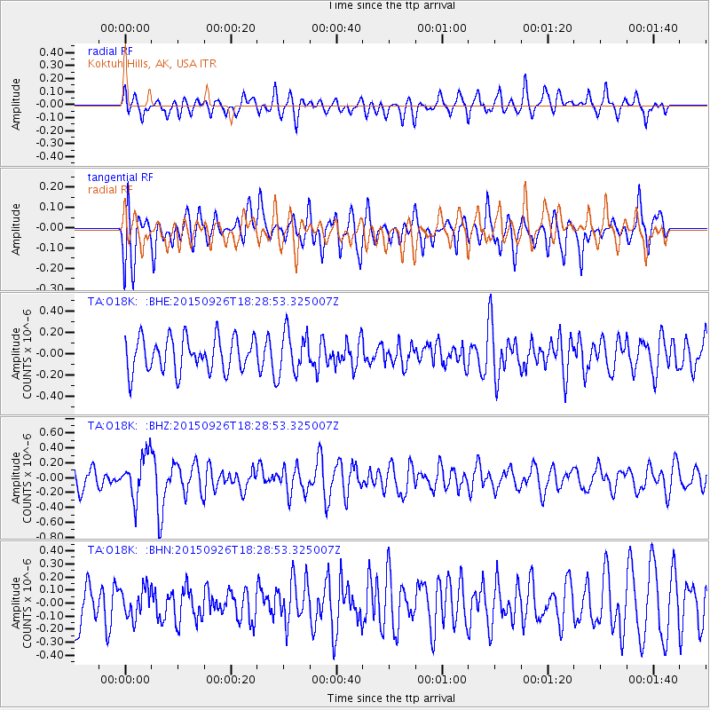
O18K Koktuh Hills, AK, USA - Earthquake Result Viewer
*The percent match for this event was below the threshold and hence no stack was calculated.
| Earthquake location: |
New Britain Region, P.N.G. |
| Earthquake latitude/longitude: |
-6.3/151.7 |
| Earthquake time(UTC): |
2015/09/26 (269) 18:17:24 GMT |
| Earthquake Depth: |
2.8 km |
| Earthquake Magnitude: |
5.5 MB |
| Earthquake Catalog/Contributor: |
NEIC PDE/NEIC COMCAT |
|
| Network: |
TA USArray Transportable Network (new EarthScope stations) |
| Station: |
O18K Koktuh Hills, AK, USA |
| Lat/Lon: |
59.85 N/155.21 W |
| Elevation: |
544 m |
|
| Distance: |
78.0 deg |
| Az: |
24.375 deg |
| Baz: |
234.378 deg |
| Ray Param: |
$rayparam |
*The percent match for this event was below the threshold and hence was not used in the summary stack. |
|
| Radial Match: |
54.20671 % |
| Radial Bump: |
400 |
| Transverse Match: |
58.316254 % |
| Transverse Bump: |
400 |
| SOD ConfigId: |
7422571 |
| Insert Time: |
2019-04-21 00:58:43.175 +0000 |
| GWidth: |
2.5 |
| Max Bumps: |
400 |
| Tol: |
0.001 |
|
Signal To Noise
| Channel | StoN | STA | LTA |
| TA:O18K: :BHZ:20150926T18:28:53.325007Z | 2.2047675 | 2.8867746E-7 | 1.3093329E-7 |
| TA:O18K: :BHN:20150926T18:28:53.325007Z | 0.5908302 | 1.11372145E-7 | 1.885011E-7 |
| TA:O18K: :BHE:20150926T18:28:53.325007Z | 1.2270086 | 1.9353025E-7 | 1.5772527E-7 |
| Arrivals |
| Ps | |
| PpPs | |
| PsPs/PpSs | |


