You are here: Home > Network List > IU - Global Seismograph Network (GSN - IRIS/USGS) Stations List
> Station NWAO Narrogin, Australia > Earthquake Result Viewer
NWAO Narrogin, Australia - Earthquake Result Viewer
| Earthquake location: |
Halmahera, Indonesia |
| Earthquake latitude/longitude: |
1.0/127.7 |
| Earthquake time(UTC): |
1994/01/21 (021) 02:24:31 GMT |
| Earthquake Depth: |
33 km |
| Earthquake Magnitude: |
7.2 MS, 7.0 UNKNOWN |
| Earthquake Catalog/Contributor: |
WHDF/NEIC |
|
| Network: |
IU Global Seismograph Network (GSN - IRIS/USGS) |
| Station: |
NWAO Narrogin, Australia |
| Lat/Lon: |
32.93 S/117.23 E |
| Elevation: |
265 m |
|
| Distance: |
35.2 deg |
| Az: |
195.423 deg |
| Baz: |
18.432 deg |
| Ray Param: |
0.0772984 |
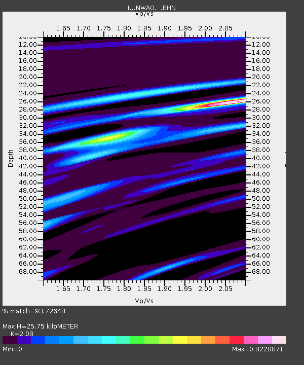
| Estimated Moho Depth: |
25.75 km |
| Estimated Crust Vp/Vs: |
2.08 |
| Assumed Crust Vp: |
6.419 km/s |
| Estimated Crust Vs: |
3.086 km/s |
| Estimated Crust Poisson's Ratio: |
0.35 |
|
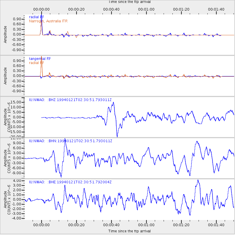
| Radial Match: |
93.72648 % |
| Radial Bump: |
191 |
| Transverse Match: |
75.03358 % |
| Transverse Bump: |
400 |
| SOD ConfigId: |
16938 |
| Insert Time: |
2010-03-04 20:44:53.643 +0000 |
| GWidth: |
2.5 |
| Max Bumps: |
400 |
| Tol: |
0.001 |
|
Signal To Noise
| Channel | StoN | STA | LTA |
| IU:NWAO: :BHN:19940121T02:30:51.793011Z | 5.4869027 | 8.3571206E-7 | 1.5231035E-7 |
| IU:NWAO: :BHE:19940121T02:30:51.792004Z | 1.167594 | 2.367468E-7 | 2.0276467E-7 |
| IU:NWAO: :BHZ:19940121T02:30:51.793011Z | 4.4715257 | 1.0917091E-6 | 2.441469E-7 |
| Arrivals |
| Ps | 4.6 SECOND |
| PpPs | 12 SECOND |
| PsPs/PpSs | 16 SECOND |


