You are here: Home > Network List > AZ - ANZA Regional Network Stations List
> Station SMER AZ.SMER > Earthquake Result Viewer
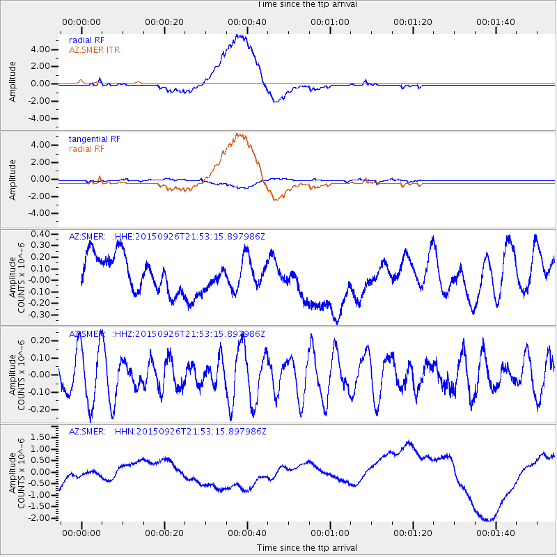
SMER AZ.SMER - Earthquake Result Viewer
*The percent match for this event was below the threshold and hence no stack was calculated.
| Earthquake location: |
Pacific-Antarctic Ridge |
| Earthquake latitude/longitude: |
-57.1/-142.4 |
| Earthquake time(UTC): |
2015/09/26 (269) 21:40:35 GMT |
| Earthquake Depth: |
10 km |
| Earthquake Magnitude: |
6.0 MWC, 5.9 MWB, 6.0 MWC |
| Earthquake Catalog/Contributor: |
NEIC PDE/NEIC COMCAT |
|
| Network: |
AZ ANZA Regional Network |
| Station: |
SMER AZ.SMER |
| Lat/Lon: |
33.46 N/117.17 W |
| Elevation: |
355 m |
|
| Distance: |
92.7 deg |
| Az: |
20.93 deg |
| Baz: |
193.488 deg |
| Ray Param: |
$rayparam |
*The percent match for this event was below the threshold and hence was not used in the summary stack. |
|
| Radial Match: |
22.214174 % |
| Radial Bump: |
400 |
| Transverse Match: |
49.597282 % |
| Transverse Bump: |
400 |
| SOD ConfigId: |
7422571 |
| Insert Time: |
2019-04-21 01:01:27.831 +0000 |
| GWidth: |
2.5 |
| Max Bumps: |
400 |
| Tol: |
0.001 |
|
Signal To Noise
| Channel | StoN | STA | LTA |
| AZ:SMER: :HHZ:20150926T21:53:15.897986Z | 2.413565 | 1.7940671E-7 | 7.433266E-8 |
| AZ:SMER: :HHN:20150926T21:53:15.897986Z | 0.34822986 | 2.7201946E-7 | 7.811492E-7 |
| AZ:SMER: :HHE:20150926T21:53:15.897986Z | 0.68872017 | 1.05907475E-7 | 1.5377432E-7 |
| Arrivals |
| Ps | |
| PpPs | |
| PsPs/PpSs | |


