You are here: Home > Network List > WY - Yellowstone Wyoming Seismic Network Stations List
> Station YHL Hebgen Lake, YNP, WY, USA > Earthquake Result Viewer
YHL Hebgen Lake, YNP, WY, USA - Earthquake Result Viewer
| Earthquake location: |
Solomon Islands |
| Earthquake latitude/longitude: |
-11.1/163.7 |
| Earthquake time(UTC): |
2015/05/22 (142) 21:45:18 GMT |
| Earthquake Depth: |
7.9 km |
| Earthquake Magnitude: |
6.8 MO |
| Earthquake Catalog/Contributor: |
NEIC PDE/NEIC ALERT |
|
| Network: |
WY Yellowstone Wyoming Seismic Network |
| Station: |
YHL Hebgen Lake, YNP, WY, USA |
| Lat/Lon: |
44.85 N/111.18 W |
| Elevation: |
2691 m |
|
| Distance: |
94.3 deg |
| Az: |
45.296 deg |
| Baz: |
258.756 deg |
| Ray Param: |
0.041076083 |
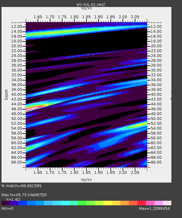
| Estimated Moho Depth: |
45.75 km |
| Estimated Crust Vp/Vs: |
1.62 |
| Assumed Crust Vp: |
6.35 km/s |
| Estimated Crust Vs: |
3.92 km/s |
| Estimated Crust Poisson's Ratio: |
0.19 |
|
| Radial Match: |
88.681595 % |
| Radial Bump: |
400 |
| Transverse Match: |
68.429634 % |
| Transverse Bump: |
400 |
| SOD ConfigId: |
976571 |
| Insert Time: |
2015-06-05 22:34:16.409 +0000 |
| GWidth: |
2.5 |
| Max Bumps: |
400 |
| Tol: |
0.001 |
|

Signal To Noise
| Channel | StoN | STA | LTA |
| WY:YHL:01:HHZ:20150522T21:58:06.86803Z | 3.3018174 | 8.734848E-9 | 2.6454667E-9 |
| WY:YHL:01:HHN:20150522T21:58:06.86803Z | 0.8570437 | 5.423795E-9 | 6.3284933E-9 |
| WY:YHL:01:HHE:20150522T21:58:06.86803Z | 0.67603487 | 4.27264E-9 | 6.3201475E-9 |
| Arrivals |
| Ps | 4.6 SECOND |
| PpPs | 18 SECOND |
| PsPs/PpSs | 23 SECOND |


