You are here: Home > Network List > TA - USArray Transportable Network (new EarthScope stations) Stations List
> Station 435B Jarrell, TX, USA > Earthquake Result Viewer
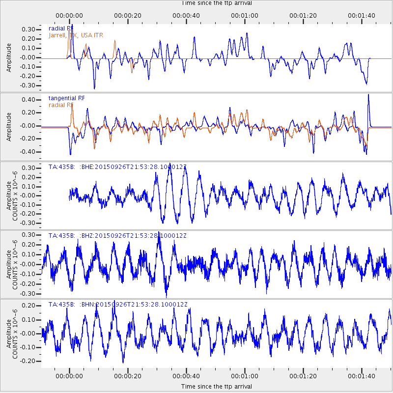
435B Jarrell, TX, USA - Earthquake Result Viewer
*The percent match for this event was below the threshold and hence no stack was calculated.
| Earthquake location: |
Pacific-Antarctic Ridge |
| Earthquake latitude/longitude: |
-57.1/-142.4 |
| Earthquake time(UTC): |
2015/09/26 (269) 21:40:35 GMT |
| Earthquake Depth: |
10 km |
| Earthquake Magnitude: |
6.0 MWC, 5.9 MWB, 6.0 MWC |
| Earthquake Catalog/Contributor: |
NEIC PDE/NEIC COMCAT |
|
| Network: |
TA USArray Transportable Network (new EarthScope stations) |
| Station: |
435B Jarrell, TX, USA |
| Lat/Lon: |
30.78 N/97.58 W |
| Elevation: |
248 m |
|
| Distance: |
95.4 deg |
| Az: |
37.566 deg |
| Baz: |
202.747 deg |
| Ray Param: |
$rayparam |
*The percent match for this event was below the threshold and hence was not used in the summary stack. |
|
| Radial Match: |
61.991528 % |
| Radial Bump: |
400 |
| Transverse Match: |
45.841614 % |
| Transverse Bump: |
400 |
| SOD ConfigId: |
7422571 |
| Insert Time: |
2019-04-21 01:03:43.978 +0000 |
| GWidth: |
2.5 |
| Max Bumps: |
400 |
| Tol: |
0.001 |
|
Signal To Noise
| Channel | StoN | STA | LTA |
| TA:435B: :BHZ:20150926T21:53:28.100012Z | 1.5367042 | 1.3558582E-7 | 8.8231566E-8 |
| TA:435B: :BHN:20150926T21:53:28.100012Z | 0.5623262 | 7.972053E-8 | 1.417692E-7 |
| TA:435B: :BHE:20150926T21:53:28.100012Z | 3.7364094 | 2.1034018E-7 | 5.6294734E-8 |
| Arrivals |
| Ps | |
| PpPs | |
| PsPs/PpSs | |


