You are here: Home > Network List > IU - Global Seismograph Network (GSN - IRIS/USGS) Stations List
> Station NWAO Narrogin, Australia > Earthquake Result Viewer
NWAO Narrogin, Australia - Earthquake Result Viewer
| Earthquake location: |
Solomon Islands |
| Earthquake latitude/longitude: |
-5.8/154.2 |
| Earthquake time(UTC): |
1995/08/16 (228) 10:27:26 GMT |
| Earthquake Depth: |
16 km |
| Earthquake Magnitude: |
6.4 MB, 7.8 MS, 7.8 UNKNOWN, 7.8 MW |
| Earthquake Catalog/Contributor: |
WHDF/NEIC |
|
| Network: |
IU Global Seismograph Network (GSN - IRIS/USGS) |
| Station: |
NWAO Narrogin, Australia |
| Lat/Lon: |
32.93 S/117.23 E |
| Elevation: |
265 m |
|
| Distance: |
43.7 deg |
| Az: |
227.064 deg |
| Baz: |
60.007 deg |
| Ray Param: |
0.0723596 |
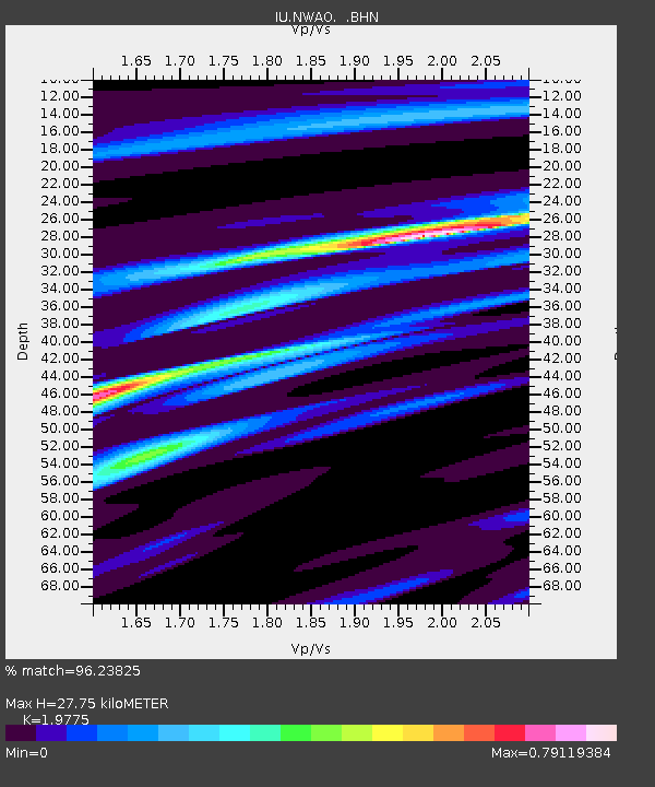
| Estimated Moho Depth: |
27.75 km |
| Estimated Crust Vp/Vs: |
1.98 |
| Assumed Crust Vp: |
6.419 km/s |
| Estimated Crust Vs: |
3.246 km/s |
| Estimated Crust Poisson's Ratio: |
0.33 |
|
| Radial Match: |
96.23825 % |
| Radial Bump: |
258 |
| Transverse Match: |
89.669846 % |
| Transverse Bump: |
400 |
| SOD ConfigId: |
6273 |
| Insert Time: |
2010-03-04 20:45:35.363 +0000 |
| GWidth: |
2.5 |
| Max Bumps: |
400 |
| Tol: |
0.001 |
|
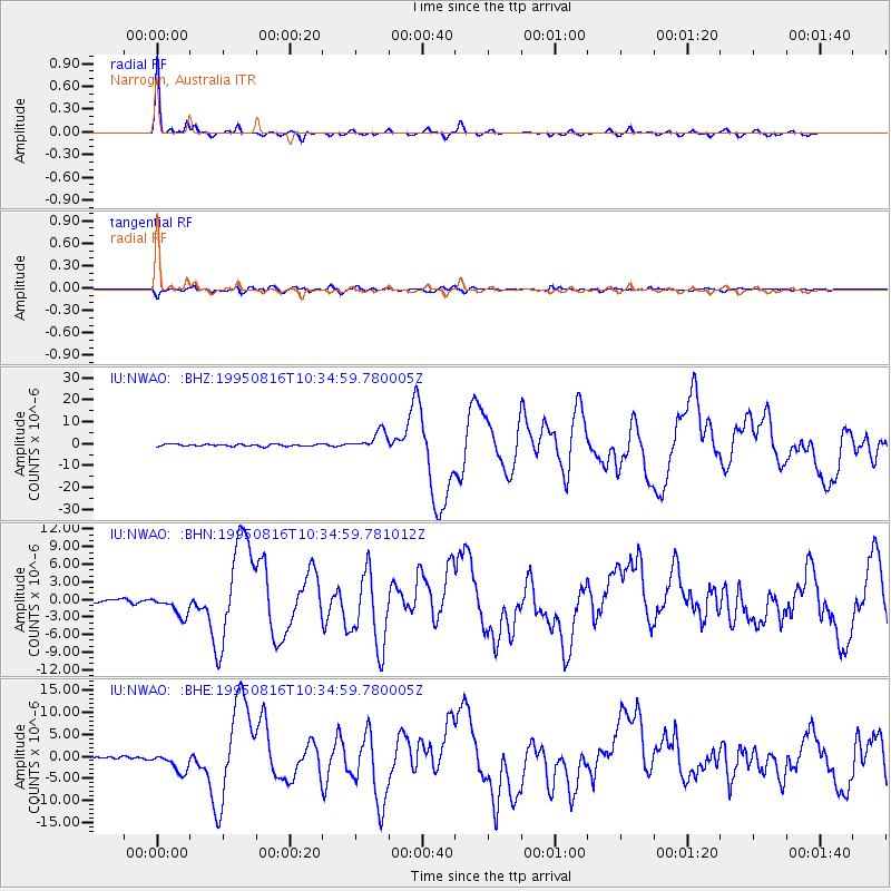
Signal To Noise
| Channel | StoN | STA | LTA |
| IU:NWAO: :BHN:19950816T10:34:59.781012Z | 6.8459196 | 1.8313473E-6 | 2.675093E-7 |
| IU:NWAO: :BHE:19950816T10:34:59.780005Z | 6.329672 | 2.2460729E-6 | 3.5484825E-7 |
| IU:NWAO: :BHZ:19950816T10:34:59.780005Z | 9.261641 | 4.1601156E-6 | 4.4917695E-7 |
| Arrivals |
| Ps | 4.5 SECOND |
| PpPs | 12 SECOND |
| PsPs/PpSs | 17 SECOND |


