You are here: Home > Network List > IU - Global Seismograph Network (GSN - IRIS/USGS) Stations List
> Station NWAO Narrogin, Australia > Earthquake Result Viewer
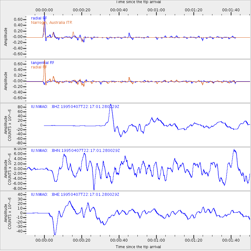
NWAO Narrogin, Australia - Earthquake Result Viewer

| Earthquake location: |
Tonga Islands |
| Earthquake latitude/longitude: |
-15.2/-173.6 |
| Earthquake time(UTC): |
1995/04/07 (097) 22:06:58 GMT |
| Earthquake Depth: |
31 km |
| Earthquake Magnitude: |
6.7 MB, 8.0 MS, 7.5 UNKNOWN, 7.1 MD |
| Earthquake Catalog/Contributor: |
WHDF/NEIC |
|
| Network: |
IU Global Seismograph Network (GSN - IRIS/USGS) |
| Station: |
NWAO Narrogin, Australia |
| Lat/Lon: |
32.93 S/117.23 E |
| Elevation: |
265 m |
|
| Distance: |
64.6 deg |
| Az: |
240.514 deg |
| Baz: |
92.109 deg |
| Ray Param: |
0.05879612 |
| Estimated Moho Depth: |
38.75 km |
| Estimated Crust Vp/Vs: |
1.81 |
| Assumed Crust Vp: |
6.419 km/s |
| Estimated Crust Vs: |
3.556 km/s |
| Estimated Crust Poisson's Ratio: |
0.28 |
|
| Radial Match: |
98.125755 % |
| Radial Bump: |
302 |
| Transverse Match: |
89.893974 % |
| Transverse Bump: |
398 |
| SOD ConfigId: |
6273 |
| Insert Time: |
2010-03-04 20:45:40.917 +0000 |
| GWidth: |
2.5 |
| Max Bumps: |
400 |
| Tol: |
0.001 |
|
Signal To Noise
| Channel | StoN | STA | LTA |
| IU:NWAO: :BHN:19950407T22:17:01.280029Z | 2.4889333 | 7.193203E-7 | 2.890075E-7 |
| IU:NWAO: :BHE:19950407T22:17:01.280029Z | 16.338686 | 6.6280486E-6 | 4.05666E-7 |
| IU:NWAO: :BHZ:19950407T22:17:01.280029Z | 23.185017 | 1.4586415E-5 | 6.2913114E-7 |
| Arrivals |
| Ps | 5.1 SECOND |
| PpPs | 16 SECOND |
| PsPs/PpSs | 21 SECOND |


