NWAO Narrogin, Australia - Earthquake Result Viewer
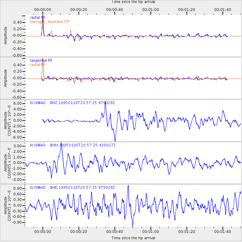
Earthquake location: Near S. Coast Of Western Honshu
Earthquake latitude/longitude: 34.5/135.0
Earthquake time(UTC): 1995/01/16 (016) 20:46:51 GMT
Earthquake Depth: 16 km
Earthquake Magnitude: 6.4 MB, 6.8 MS, 6.5 UNKNOWN, 6.9 MW
Earthquake Catalog/Contributor: WHDF/NEIC
Network: IU Global Seismograph Network (GSN - IRIS/USGS)
Station: NWAO Narrogin, Australia
Lat/Lon: 32.93 S/117.23 E
Elevation: 265 m
Distance: 69.2 deg
Az: 195.939 deg
Baz: 15.636 deg
Ray Param: 0.055815957
Estimated Moho Depth: 29.75 km
Estimated Crust Vp/Vs: 1.96
Assumed Crust Vp: 6.419 km/s
Estimated Crust Vs: 3.271 km/s
Estimated Crust Poisson's Ratio: 0.32
Radial Match: 92.37422 %
Radial Bump: 248
Transverse Match: 77.550095 %
Transverse Bump: 400
SOD ConfigId: 6273
Insert Time: 2010-03-04 20:45:44.520 +0000
GWidth: 2.5
Max Bumps: 400
Tol: 0.001

Signal To Noise

ChannelStoNSTALTA
IU:NWAO: :BHN:19950116T20:57:25.430017Z3.69565428.7099426E-72.3568067E-7
IU:NWAO: :BHE:19950116T20:57:25.479028Z1.46773522.1263008E-71.448695E-7
IU:NWAO: :BHZ:19950116T20:57:25.479028Z9.9070092.2170464E-62.2378562E-7
Arrivals
Ps4.6 SECOND
PpPs13 SECOND
PsPs/PpSs18 SECOND