You are here: Home > Network List > TA - USArray Transportable Network (new EarthScope stations) Stations List
> Station I23K Minto, Yukon-Koyukuk, AK, USA > Earthquake Result Viewer
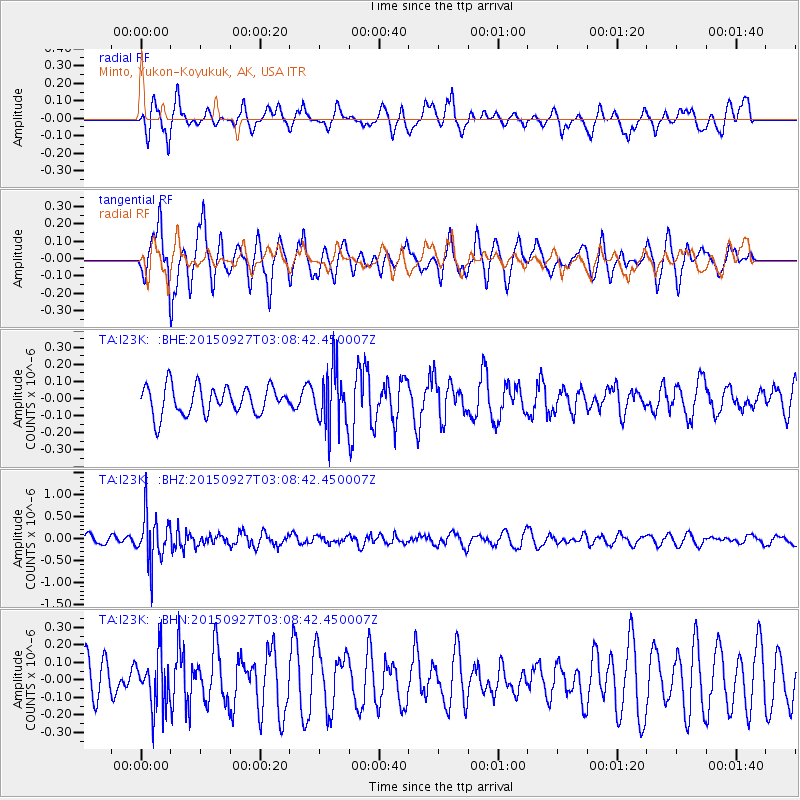
I23K Minto, Yukon-Koyukuk, AK, USA - Earthquake Result Viewer
*The percent match for this event was below the threshold and hence no stack was calculated.
| Earthquake location: |
Banda Sea |
| Earthquake latitude/longitude: |
-7.2/129.7 |
| Earthquake time(UTC): |
2015/09/27 (270) 02:56:13 GMT |
| Earthquake Depth: |
110 km |
| Earthquake Magnitude: |
5.6 MB |
| Earthquake Catalog/Contributor: |
NEIC PDE/NEIC COMCAT |
|
| Network: |
TA USArray Transportable Network (new EarthScope stations) |
| Station: |
I23K Minto, Yukon-Koyukuk, AK, USA |
| Lat/Lon: |
65.15 N/149.36 W |
| Elevation: |
149 m |
|
| Distance: |
92.7 deg |
| Az: |
24.694 deg |
| Baz: |
258.751 deg |
| Ray Param: |
$rayparam |
*The percent match for this event was below the threshold and hence was not used in the summary stack. |
|
| Radial Match: |
61.0673 % |
| Radial Bump: |
400 |
| Transverse Match: |
69.61005 % |
| Transverse Bump: |
400 |
| SOD ConfigId: |
7422571 |
| Insert Time: |
2019-04-21 01:06:54.079 +0000 |
| GWidth: |
2.5 |
| Max Bumps: |
400 |
| Tol: |
0.001 |
|
Signal To Noise
| Channel | StoN | STA | LTA |
| TA:I23K: :BHZ:20150927T03:08:42.450007Z | 4.381795 | 5.395813E-7 | 1.2314162E-7 |
| TA:I23K: :BHN:20150927T03:08:42.450007Z | 1.4272238 | 1.5085611E-7 | 1.0569899E-7 |
| TA:I23K: :BHE:20150927T03:08:42.450007Z | 2.018033 | 1.6607063E-7 | 8.229332E-8 |
| Arrivals |
| Ps | |
| PpPs | |
| PsPs/PpSs | |


