You are here: Home > Network List > TA - USArray Transportable Network (new EarthScope stations) Stations List
> Station J26L Joseph Creek, AK, USA > Earthquake Result Viewer
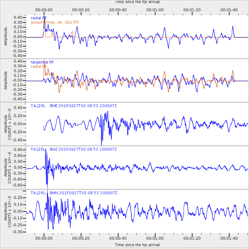
J26L Joseph Creek, AK, USA - Earthquake Result Viewer
*The percent match for this event was below the threshold and hence no stack was calculated.
| Earthquake location: |
Banda Sea |
| Earthquake latitude/longitude: |
-7.2/129.7 |
| Earthquake time(UTC): |
2015/09/27 (270) 02:56:13 GMT |
| Earthquake Depth: |
110 km |
| Earthquake Magnitude: |
5.6 MB |
| Earthquake Catalog/Contributor: |
NEIC PDE/NEIC COMCAT |
|
| Network: |
TA USArray Transportable Network (new EarthScope stations) |
| Station: |
J26L Joseph Creek, AK, USA |
| Lat/Lon: |
64.50 N/143.56 W |
| Elevation: |
1144 m |
|
| Distance: |
95.1 deg |
| Az: |
25.711 deg |
| Baz: |
263.923 deg |
| Ray Param: |
$rayparam |
*The percent match for this event was below the threshold and hence was not used in the summary stack. |
|
| Radial Match: |
40.32586 % |
| Radial Bump: |
392 |
| Transverse Match: |
54.886566 % |
| Transverse Bump: |
400 |
| SOD ConfigId: |
7422571 |
| Insert Time: |
2019-04-21 01:06:54.298 +0000 |
| GWidth: |
2.5 |
| Max Bumps: |
400 |
| Tol: |
0.001 |
|
Signal To Noise
| Channel | StoN | STA | LTA |
| TA:J26L: :BHZ:20150927T03:08:53.200007Z | 5.099105 | 3.5455935E-7 | 6.953365E-8 |
| TA:J26L: :BHN:20150927T03:08:53.200007Z | 1.1777786 | 1.2785333E-7 | 1.0855463E-7 |
| TA:J26L: :BHE:20150927T03:08:53.200007Z | 2.2625704 | 2.0328933E-7 | 8.984884E-8 |
| Arrivals |
| Ps | |
| PpPs | |
| PsPs/PpSs | |


